A Brewing Monsoon! And, What's the Latest With Our Godzilla El Niño?
Overview
My friends...
The weather this summer has been relatively uneventful thus far. The occasional mountain thunderstorm has punctuated otherwise perfect weather! However, things appear likely to become more interesting beginning next week, as a monsoonal flow pattern develops alongside a possible jolt to the Eastern Pacific hurricane season.
The Desert Southwest and Sierra Nevada are expected to experience a somewhat extended early monsoonal pattern, reaching anomalously far northwest into northwestern Nevada and the Sierra Nevada.
Additionally, I will cover my thoughts on the developing El Niño, which is already breaking some records, and what it could mean for the remainder of summer and possibly next winter. It continues to look like a historic event is afoot. If you are wondering why the word “historic” gets thrown around so much, it is because, climatologically speaking, we are truly living through unprecedented conditions. Historic is increasingly becoming the new normal...
Buckle up!
The Monsoon Arrives... and the Eastern Pacific Hurricane Season Awakens?
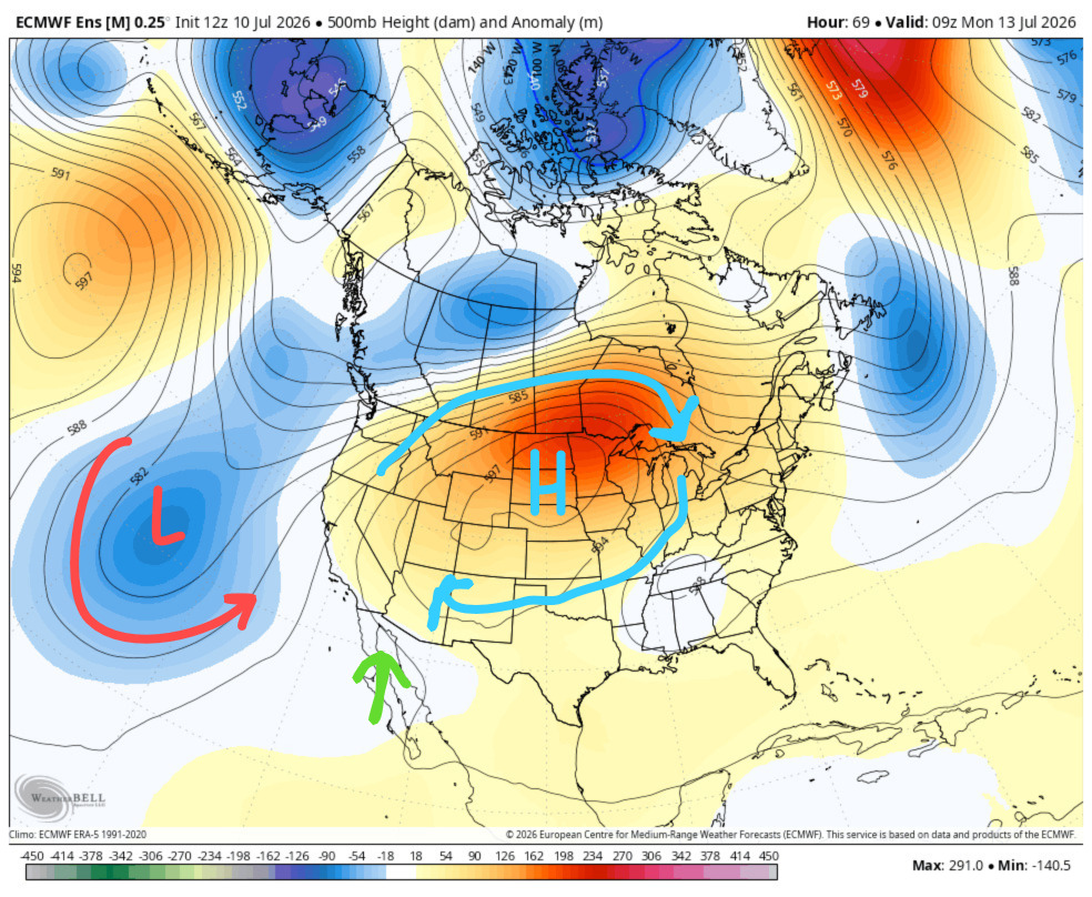
An interesting setup is currently developing as a very high-amplitude heat dome forms over the Plains. This could cause parts of Montana to approach 111°F.
While above-average heat will dominate much of the West, a co-occurring trough off the coast of California will establish a broad flow pattern favorable for transporting monsoonal moisture into the Desert Southwest and Sierra Nevada. This pattern draws warm, moist air northward from the Gulf of California.
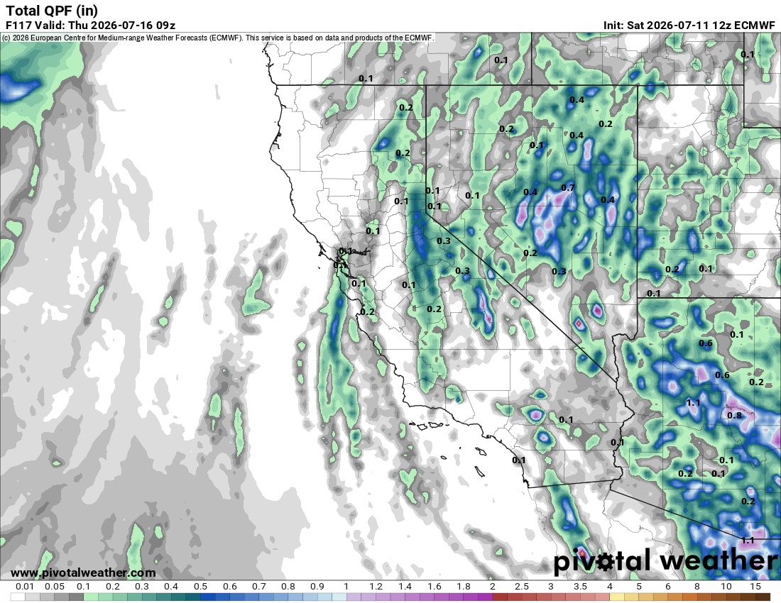
In the near term, the strongest pulse of moisture into the Eastern Sierra looks likely from Monday through Tuesday. Many models show some areas near the Sierra Crest receiving close to 1" of rain during this period, with totals of several tenths of an inch scattered across the Sierra Nevada and Great Basin.
Because this is convective precipitation, totals will be highly uneven. Some locations could receive more than an inch while nearby areas receive very little.
For the Eastern Sierra, thunderstorm coverage should increase Monday and Tuesday, especially during the afternoon and evening. The primary concerns will be lightning, locally heavy rain, gusty outflow winds, and briefly heavy downpours.
Hikers, climbers, and anyone spending time above treeline should pay attention to storm development and be prepared to descend before thunderstorms arrive.
After Tuesday, the monsoon appears likely to continue, primarily affecting the Desert Southwest, but with occasional surges of moisture reaching the Sierra Nevada.
Ensembles reflect this pattern, with positive precipitation anomalies across much of the Southwest!
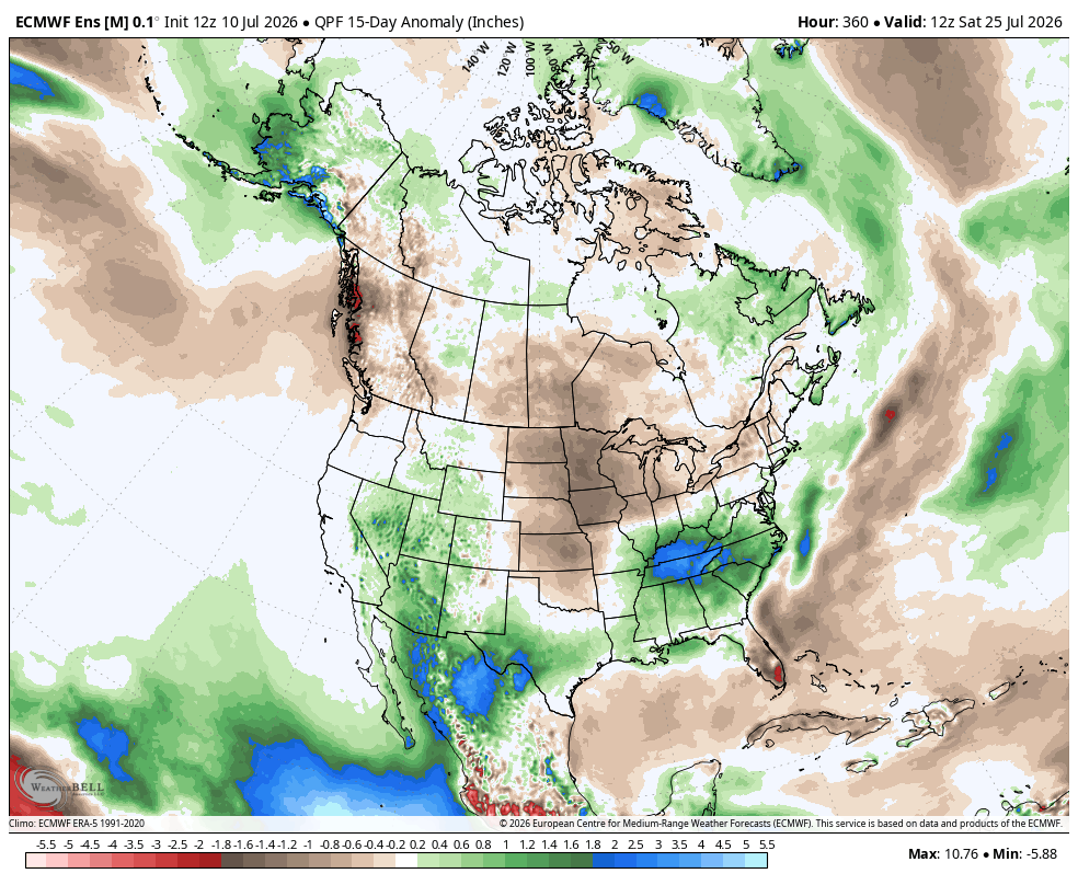
It remains to be seen if this pattern will be transient or become more established.
This pattern becomes even more interesting when we look at the Eastern Pacific hurricane season, which may be waking up.
In the animation below, you can see possible tropical-system development depicted by the European ensemble. Many Eastern Pacific systems eventually move west-northwest over open water. Occasionally, their moisture, and less commonly their remnants, can be drawn northward into Mexico, the Desert Southwest, or California.
In the European AI model, we can see one particularly interesting scenario, with the remnants of a tropical system moving toward California...
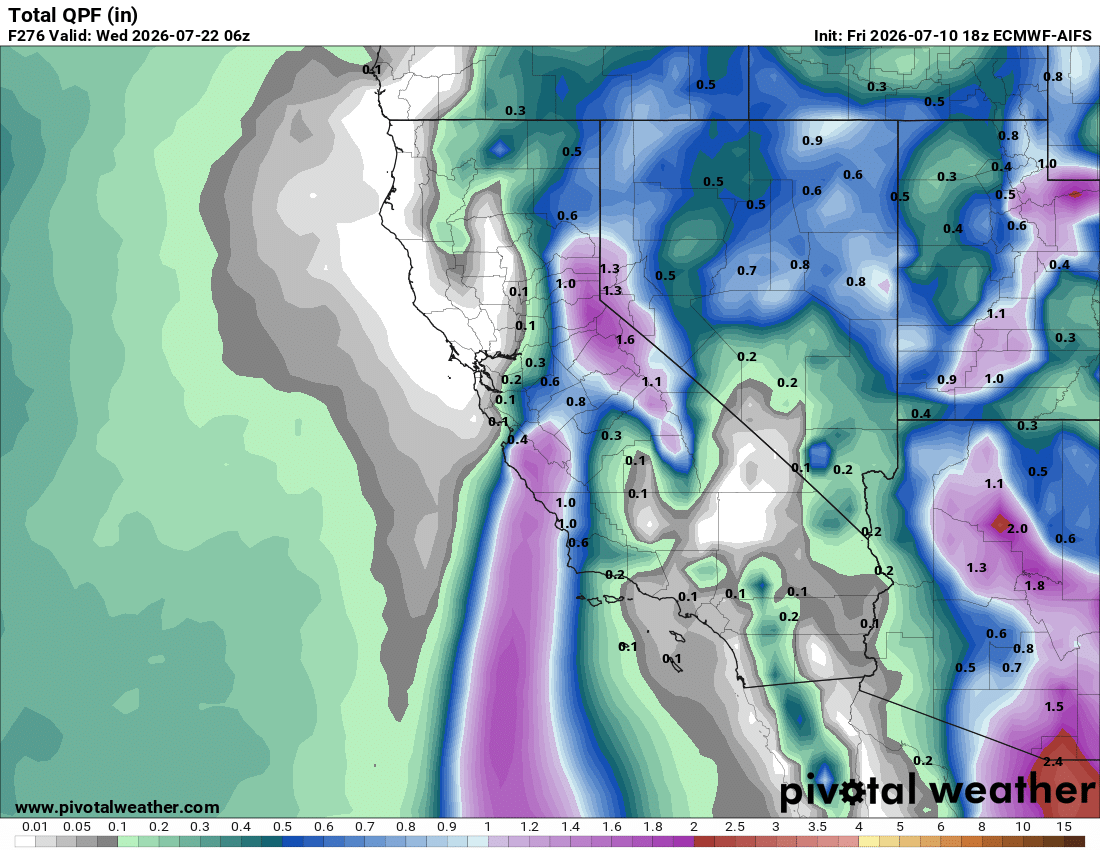
This is not currently the favored outcome. However, this type of connection will become increasingly likely later in August and September, when the Eastern Pacific hurricane season is typically more active and the monsoon is generally better established.
Several forecasting signals and recent model runs suggest that Eastern Pacific activity may increase substantially later this summer, particularly as El Niño strengthens. The positive Pacific Meridional Mode (warm waters off the coast of Baja) and our developing historic El Niño could both help create a more favorable background environment later this season.
But let’s talk about that!
El Niño: Godzilla or a Run-of-the-Mill Event?
My friends...
It has been a while since I last talked about El Niño.
At this point in summer, we are typically well beyond the “spring predictability barrier,” during which El Niño forecasts can fail because of elevated uncertainty.
Models have now latched onto exceptionally strong solutions for the development of this El Niño. The European seasonal model and CFSv2 both include outcomes that would rival or exceed the strongest events in the modern observational record.
Put simply: I strongly believe we are headed toward a historic-strength El Niño. A record-setting peak is not guaranteed, but at this point I think it is more likely than not that this event will rank among the strongest in the modern record.
The exact peak and downstream impacts remain uncertain.
But First, What Is El Niño?
El Niño is the warm phase of ENSO, a coupled ocean–atmosphere pattern in the tropical Pacific.
NOAA identifies an event when temperatures in the Niño-3.4 region remain sufficiently above average across multiple overlapping three-month periods and the tropical atmosphere exhibits a corresponding El Niño response.
El Niño strength is commonly described using approximate categories:
- Moderate: at least +1.0°C
- Strong: at least +1.5°C
- Very strong, sometimes called “super”: at least +2.0°C
These categories generally refer to sustained seasonal values rather than a single daily observation.
The 2015–16 event was one of the strongest El Niños in the modern observational record, alongside 1982–83 and 1997–98.
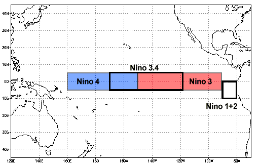
The key monitoring area is the Niño-3.4 region, which is important for determining how strongly atmospheric circulation couples and shifts from a background state.
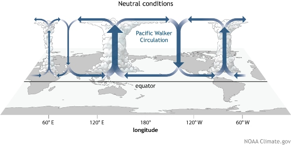
Under normal conditions, the Walker circulation features broad rising motion and tropical convection near the Maritime Continent, with greater subsidence over the central and eastern equatorial Pacific.
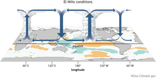
During El Niño, unusually warm water in the central and eastern Pacific shifts tropical convection substantially eastward. Rising motion develops in areas that typically experience more subsidence, reorganizing tropical circulation.
One direct result of this is a stronger and more active subtropical jet stream, which creates and steers Pacific storms toward the southern United States.
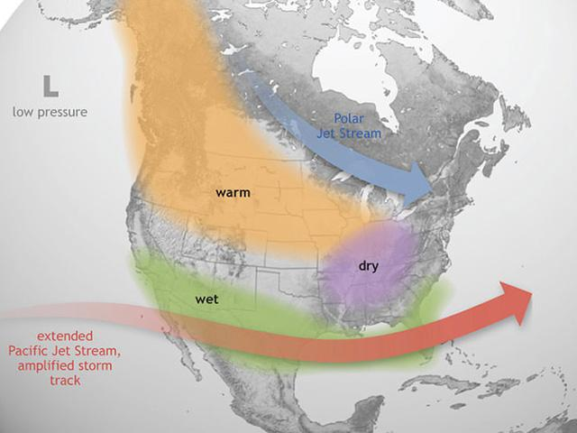
The textbook response to El Niño favors wetter conditions across California, the Southwest, and the Southeast, with drier conditions more likely in parts of the Pacific Northwest.
However, not all El Niños are created equal, and not all El Niños result in textbook responses.
For California, only strong El Niños reliably show a wet signal. Contrary to popular belief, the response to strong El Niños is not confined to Southern California: both the historical record and large model ensembles show wetter-than-average conditions extending across much of the state, including Northern California.
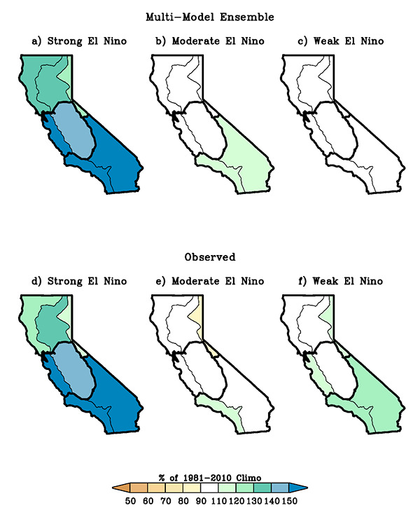
The graphic above shows the modeled and observed precipitation response as a percentage of the 1981–2010 climatology. In both the multimodel ensemble and the historical record, strong El Niños produce a broad wet signal across California.
That does not mean a wet California winter is guaranteed. Event strength alone is never sufficient to predict the outcome of a specific season. The location of tropical convection, North Pacific circulation, intraseasonal variability, and the evolution of individual storms still matter.
But from the perspective of California, strong and super El Niños are absolutely worth paying attention to. And I don't buy into much of the other ENSO based seasonal forecasting. Forecasters have a tendency to look to the textbook response as a binary for both La Niña and El Niño.
Beyond regional rainfall effects, El Niños release a tremendous amount of heat from the ocean into the atmosphere. The period during and following a strong El Niño often ranks among the warmest observed globally.
A historic El Niño could temporarily push a running global average above 2°C relative to the preindustrial period, which is an important threshold from the Paris Climate Agreements.
El Niño also tends to create a broad range of impacts around the world:
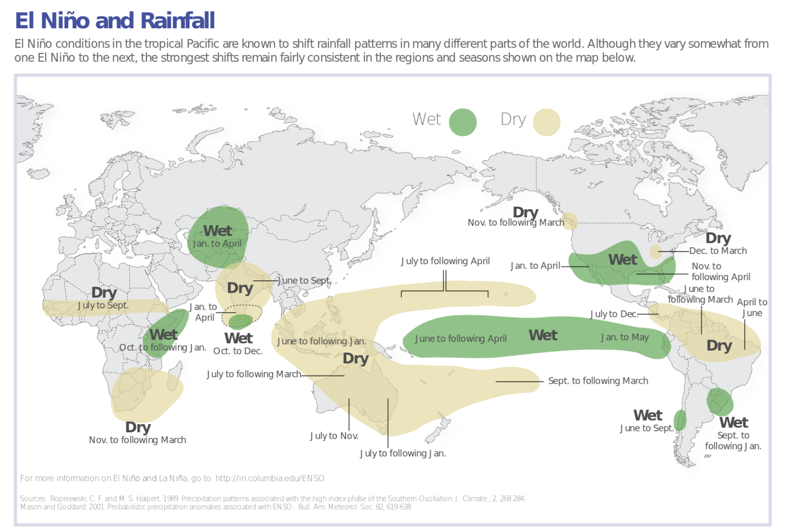
So a potential historic-strength El Niño is a very big deal globally!
But where is our Niño realistically heading?
Monster El Niño
My friends...
I truly believe we are headed into record territory. By some measures, we already are!
Daily Niño-3.4 SST anomalies reached +2.0°C on July 7 in NOAA’s OISSTv2.1 dataset, using a 1991–2020 climatology. In the OISST record beginning in 1982, the previous earliest occurrence of this threshold was August 30, 1997. 2C is the threshold for super El Niño!
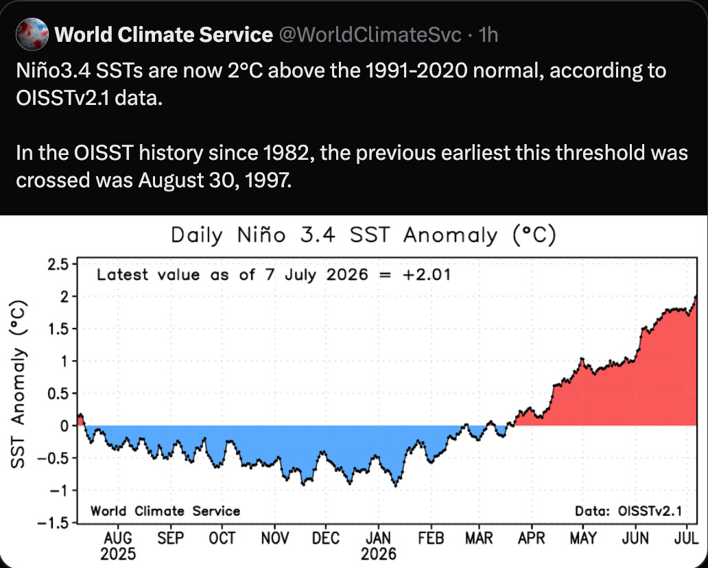
While this does not formally mean a Super El Niño has been reached, this is still an extraordinary milestone. It illustrates how unusually early and rapidly the tropical Pacific has warmed.
And then there are the model outlooks.
In the chart below, you can see forecasts for both the traditional and relative El Niño indices from the European seasonal model.
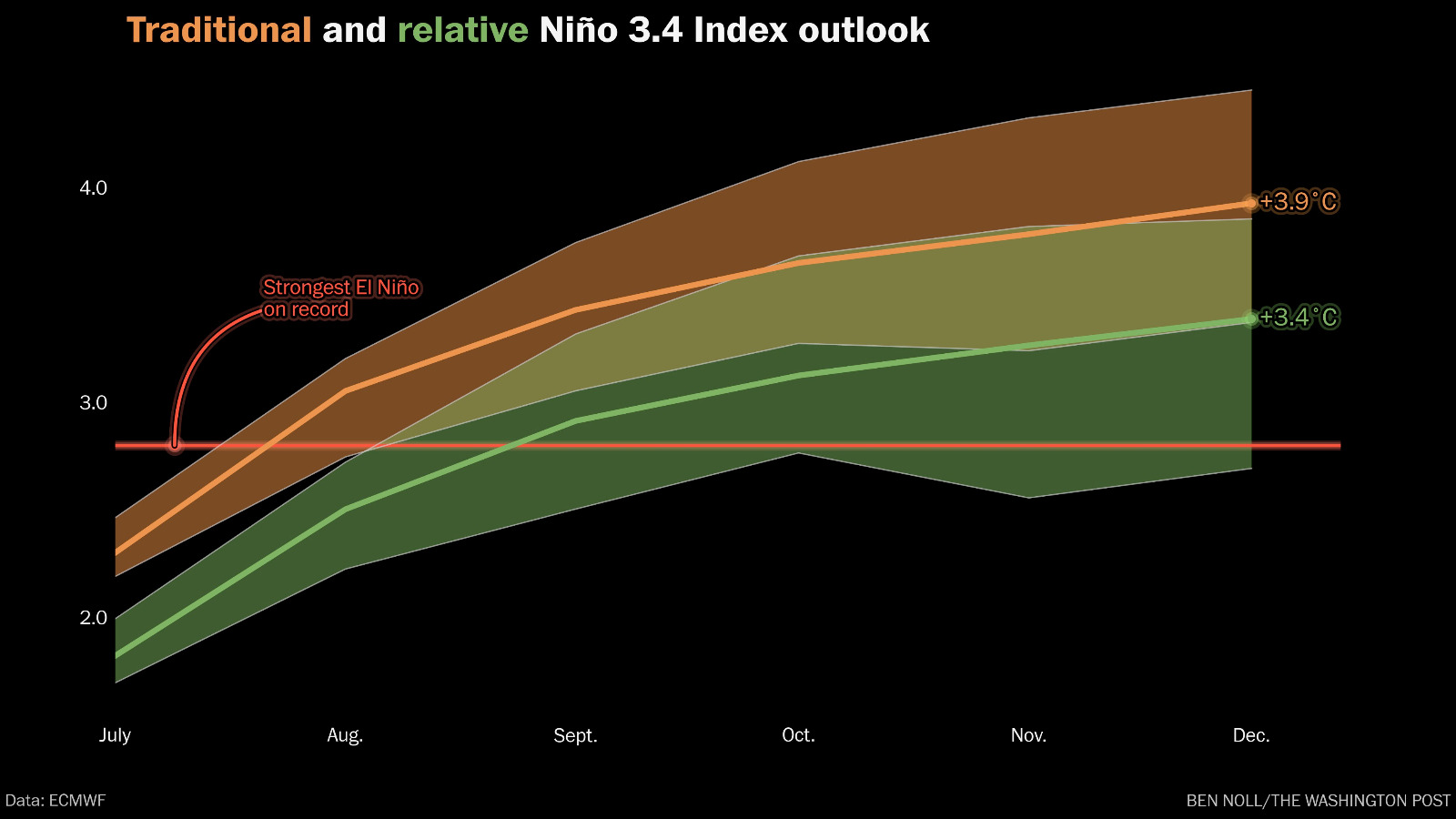
ENSO strength can be described using several related indices.
The traditional Niño-3.4 anomaly compares current sea-surface temperatures with a fixed climatological baseline. The relative index additionally accounts for the temperature of the broader tropical oceans.
That relative measure better represents the strength of an El Niño, and thus how strongly it may affect atmospheric circulation through a shifted Walker Circulation.
The European forecast reaches well above the previous record. If this forecast verifies, this event would be the strongest El Niño in the modern observational record.
Every subsequent model run has shifted upward, as the subseasonal events responsible for strengthening El Niño have repeatedly reinforced the warming:
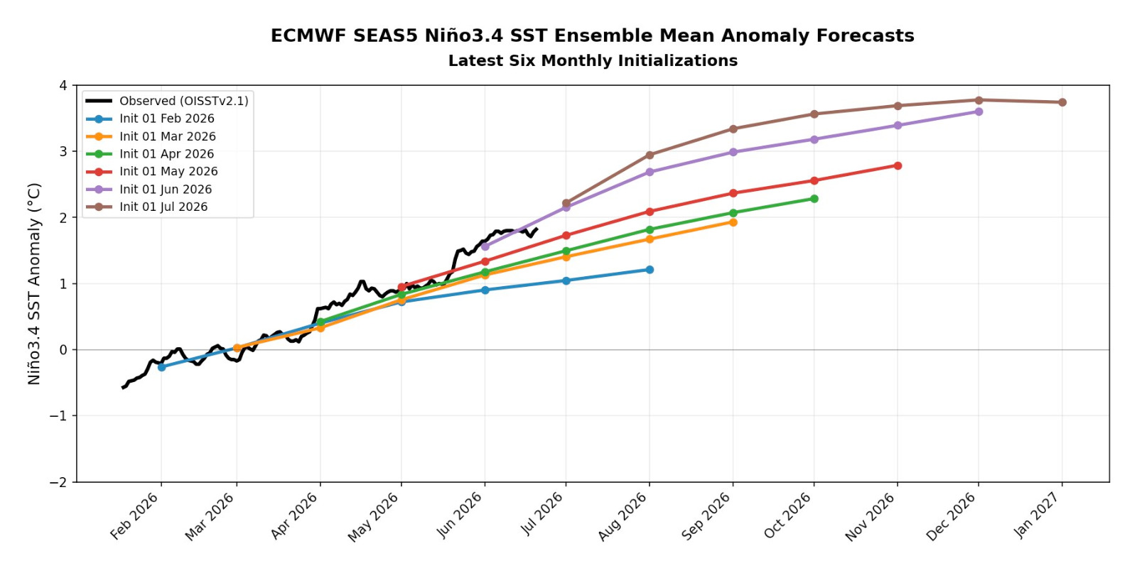
Sometimes, the spring predictability barrier works against the models in being able to see the full strength of the developing El Niño. This year appears to be one such case! The CFSv2 model average depicts a Niño exceeding +4°C, considerably beyond the previous observed record.
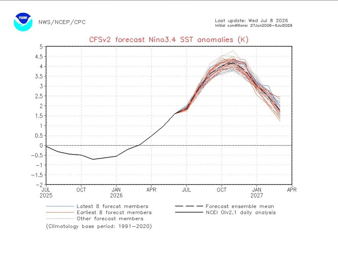
The CFS is just one model, so this extreme value is not guaranteed or even the most likely one. However, the repeated upward movement across models is meaningful, especially because it is being supported by the physical evolution of the ocean and atmosphere.
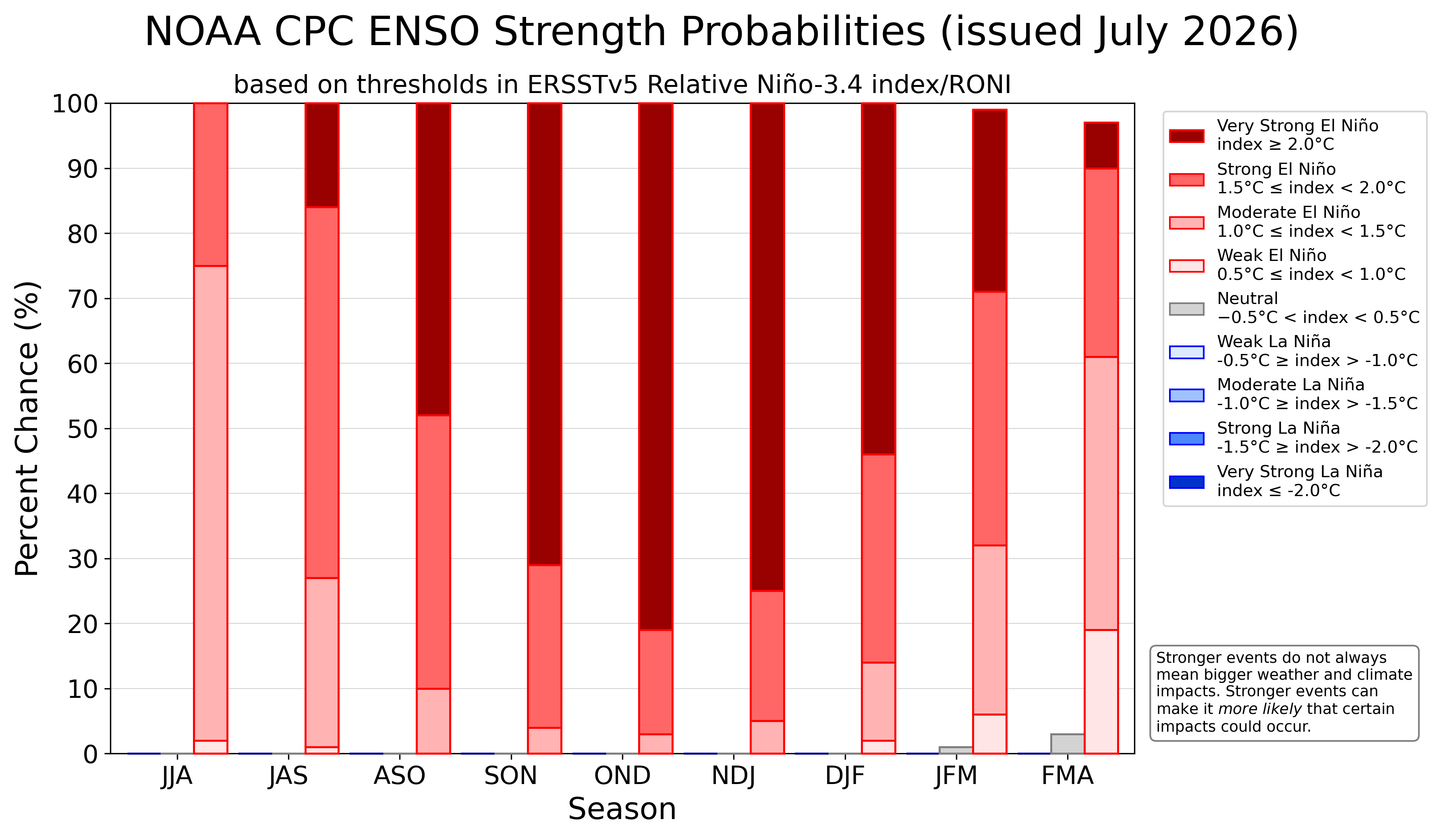
Even NOAA places the probability of a very strong El Niño developing at 81%, with near 100% certainty of at least a strong event! This is remarkably high confidence in such an event this far out.
One of the primary mechanisms responsible for strengthening El Niño is the occurrence of westerly wind bursts, or WWBs. These bursts can trigger downwelling Kelvin waves. Kelvin waves are large oceanic waves that move warm subsurface water eastward and deepen the thermocline across the central and eastern Pacific.
The chart below shows remarkably persistent westerly wind bursts, with continued presistence forecast.
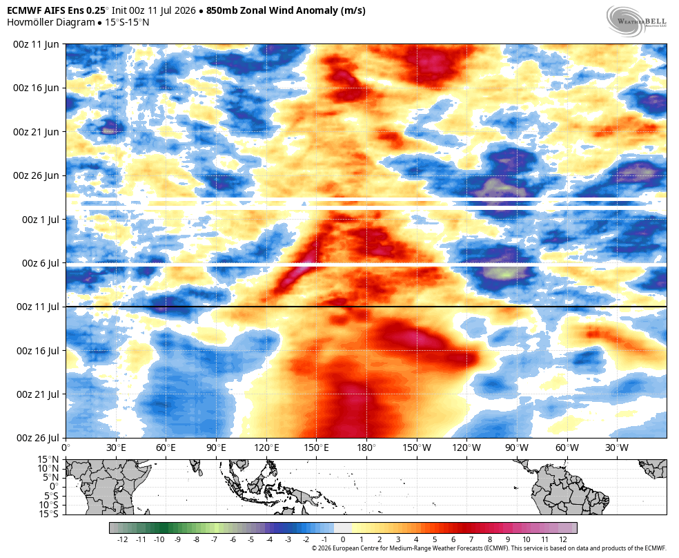
That continued forcing means further El Niño strengthening.
El Niño usually reaches its maximum strength sometime between October and December. Repeated westerly wind bursts, rapidly warming surface waters, and increasing atmospheric coupling all support substantial additional strengthening into fall.
Considering we are weeks ahead of previous record Niños, and with the length of runway it still has for development, I am compelled to believe a historic Niño is upon us.
El Hombre!
And there are signs that the broader atmosphere is already starting to couple, with distinct areas of rising and subsiding motion forming:
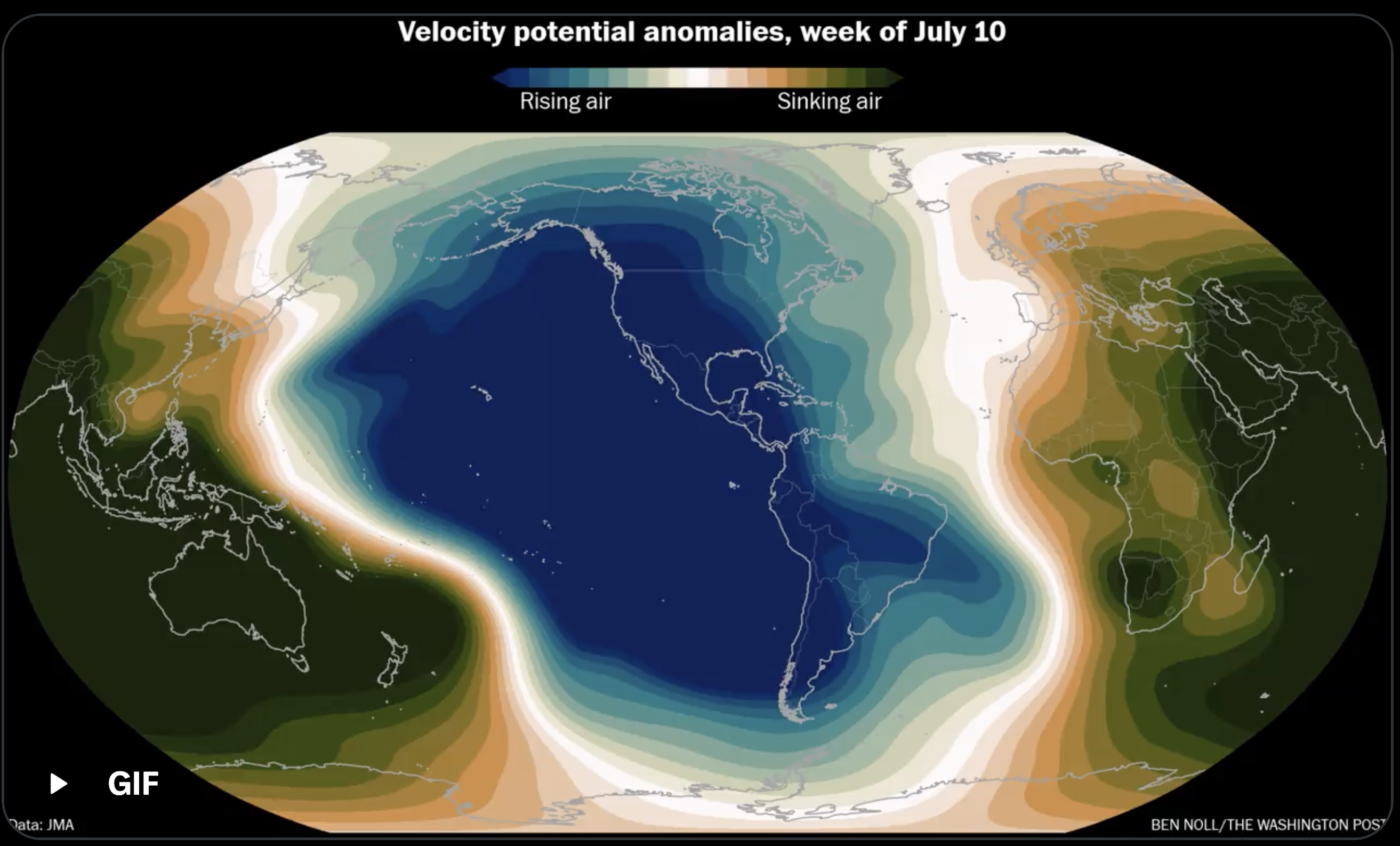
Impacts
Hopefully I have made the case that this is not pure hype and that an incredible event is developing.
Now, what could the impacts be?
Let’s begin with this summer by looking at the current sea-surface-temperature-anomaly map:
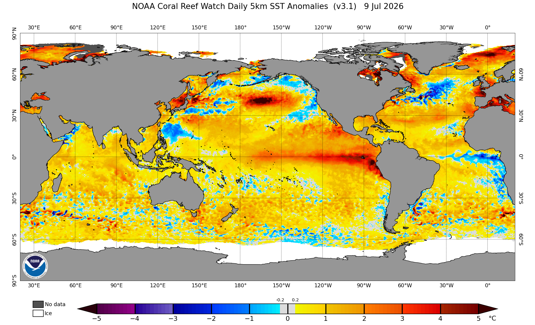
The map shows a well-developed El Niño, along with anomalously warm waters off Baja California and in the Gulf of California.
For the Eastern Pacific, this could help produce a highly favorable environment for tropical systems later this season. Once the monsoon becomes more established, warm tropical waters in the Gulf of California may also provide a more abundant moisture source, helping monsoonal moisture reach farther north. The National Hurricane Center lists a 71% chance of an above average EPAC season.
With Eastern Pacific activity expected to increase later in the season, tropical moisture or remnants may occasionally affect the Southwest and Sierra Nevada.
I am also expecting warmer-than-average temperatures across much of the United States.
Surprise!
Below are my seasonal outlook maps:
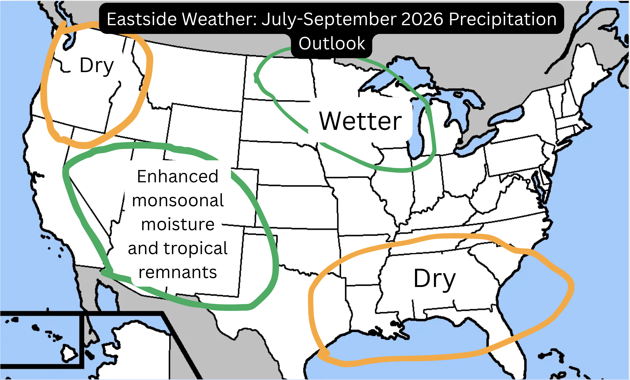
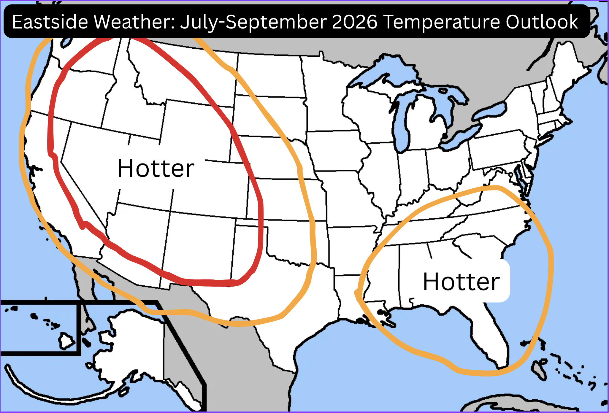
Taking a look at the Euro Seasonal, it generally aligns with my thinking for a more robust Southwest monsoon:
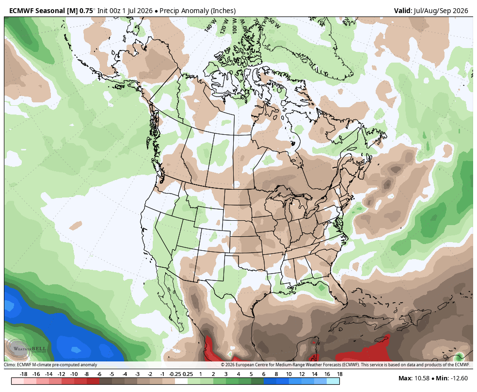
However, it differs on the midwest, which I think is slightly favored for wetter than average conditions, in part due to a Northwest flow scenario, which is seen in the monsoonal pattern we have this week. This type of ridge pattern is favored by our summer climatology, but time will tell!
Winter impacts are perhaps the more exciting question for many people reading this blog. I will caution that it is still far too soon to speak with any measure of certainty.
However, because of the expected strength of the developing El Niño, I think the atmosphere will be much more likely to exhibit a canonical response, which favors wetter conditions across California.
As a result, I think the precipitation signal shown by the seasonal models is more likely than not to be correct: drier conditions in the Pacific Northwest and wetter conditions across California, the Southwest, and the Southeast.
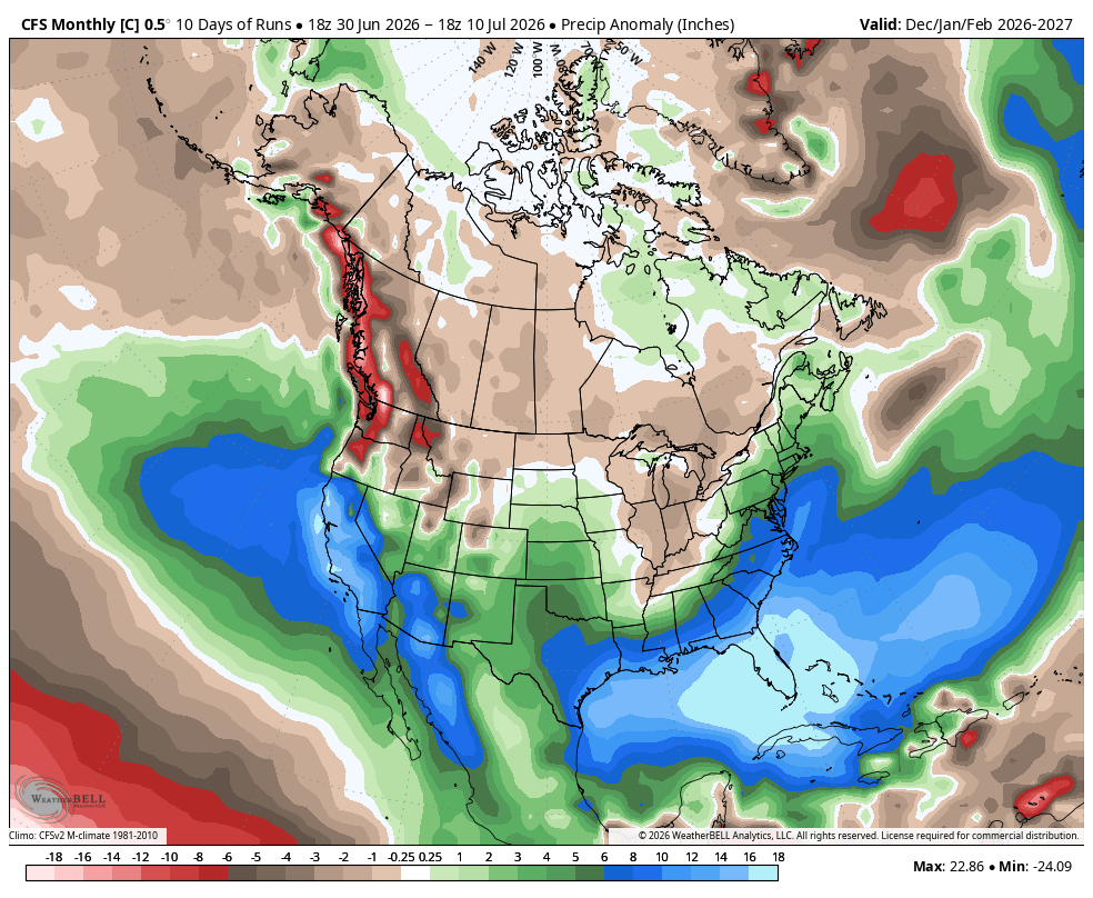
The data both in terms of historical observations and modeling strongly supports this as well. Strong El Niños have produced wetter-than-average conditions across both Southern and Northern California on average, with the strongest anomalies generally concentrated farther south.
However, I checked what seasonal models were showing at this point during the developing 2015–16 El Niño.
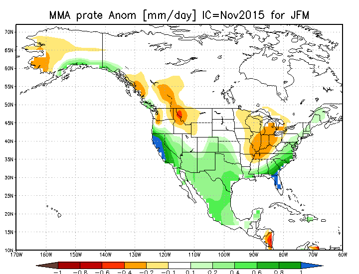
That winter ultimately produced near-average precipitation across much of California and very wet conditions in the Pacific Northwest. Yet the models at this stage were showing an outlook like what they are showing now.
That is an important reminder: seeing the "textbook" El Niño response in seasonal models does not guarantee that it will occur. Even very strong El Niños can fail to produce a wet winter across California.
Still, based on the historical record, large numerical-model ensembles, the observed statewide response to strong El Niños, and the current seasonal guidance, I believe the odds are meaningfully tilted toward wetter-than-average conditions across California next winter.
There is also the possibility that a record strength El Niño in a time of changing climate may not fit our modeled and observed understanding... So, the unexpected is certainly possible! However:
A historic-strength El Niño now looks likely. A wetter California winter is favored. And the next year of weather will be fascinating!
Key Takeaways:
Confidence is high that El Niño will continue strengthening.
Confidence is moderate that it will become a historically strong event by fall or early winter.
I believe it is more likely than not that this El Niño will rank among the strongest in the modern observational record.
Confidence is lower regarding its precise peak, whether it sets an absolute record, exactly how active the Eastern Pacific hurricane season becomes, and how precipitation and impacts are distributed.
For the immediate Eastern Sierra forecast, confidence is relatively high that monsoonal moisture and thunderstorm chances will increase Monday and Tuesday. Confidence is lower regarding rainfall at any specific location because convective precipitation will be highly uneven.
Either way...
Buckle up!