Record breaking heatwave and a glimmer of hope?
Overview
My friends...
A truly record breaking march heat dome lies ahead the next few days, and will peak mid-week next week. It will not be until the last few days of March until we have even a chance at active weather returning out west, and even still there is not much of a convincing signal in any direction. This heat wave will result in substantial snowpack loss, especially at low and mid elevations.
I also reflect on the winter down below.
Major Heatwave
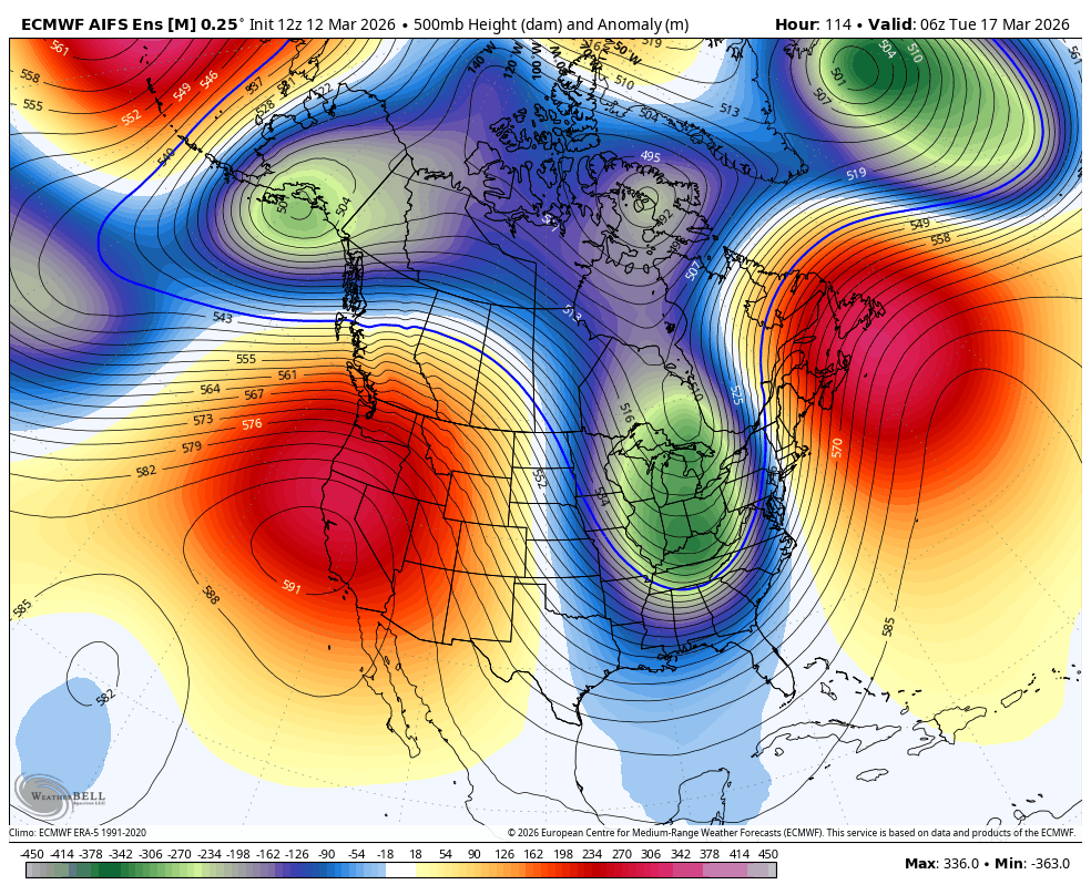
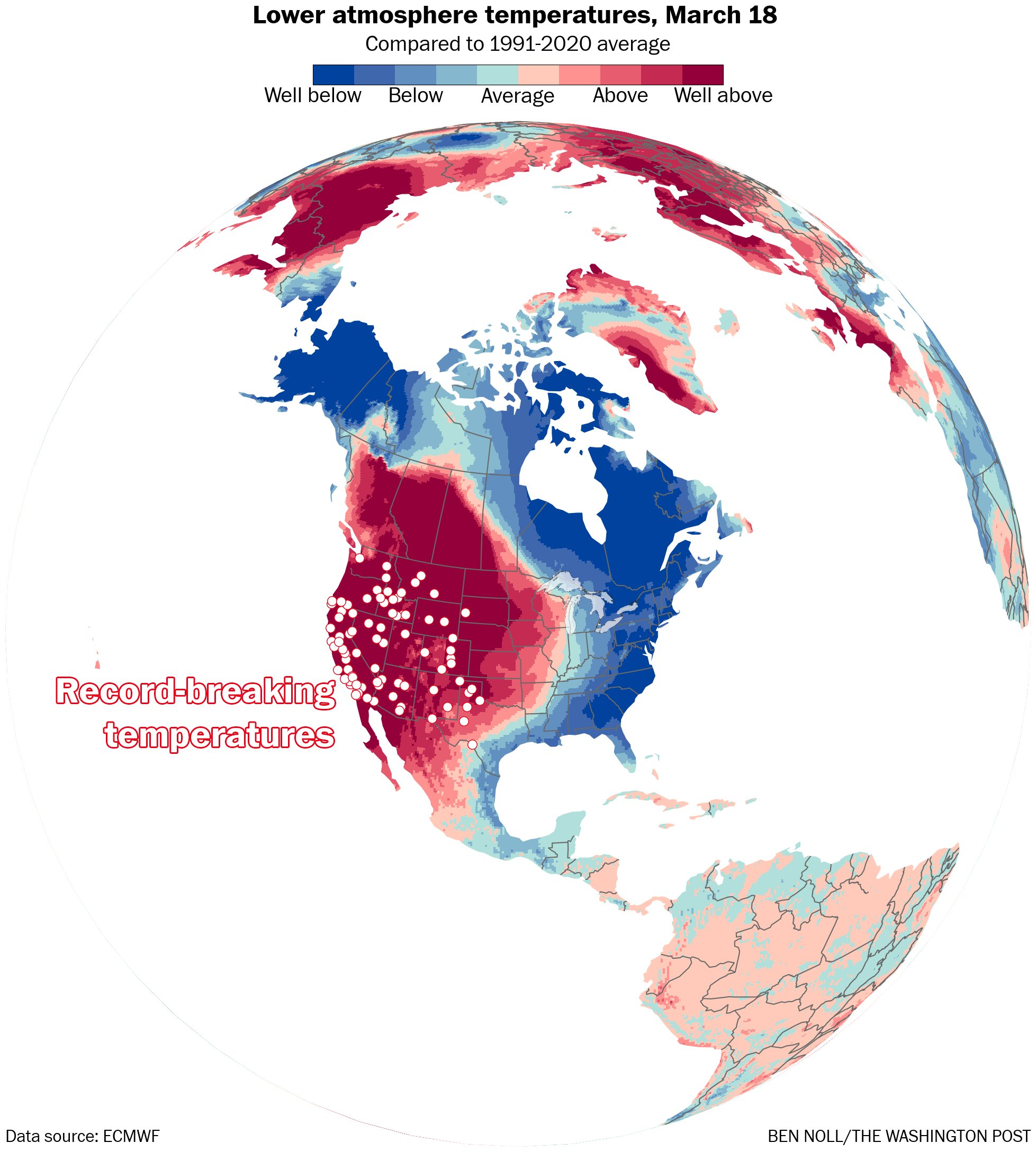
A truly monstrous march "heatdome" is building in, which will be likely to break many all-time March heat records. Las Vegas and many parts of LA county seem certain to surpass 100 degrees Fahrenheit, which is ridiculous for this time of year. From the NWS Los Angeles Area Forecast Discussion (AFD): "Both daily and monthly records could fall esp on Tue.", and "Given the unprecedented length and magnitude of this extreme heat wave, heat stress will be a real threat each day, especially in areas that aren`t used to the heat, like the coastal areas, where people may not have methods to cool off their homes."
The NWS has noted the possibility of extreme heat warnings for parts of Southern California, which look on track to receive one of the earliest extreme heat waves ever observed...
Locally here on the east side:
Mammoth Lakes will see high temps in the 70s for many days, Bishop will see high temps in the mid 80s... This heatwave looks likely to diminish in about 7-10 days...
It is all being driven by that monster ridge right overhead, and it will stay firmly planted until the last few days of March, when ensemble guidance currently hints at a north based -PNA pattern developing... This signal is more diffuse, and at nearly two weeks out is not something to count on yet.
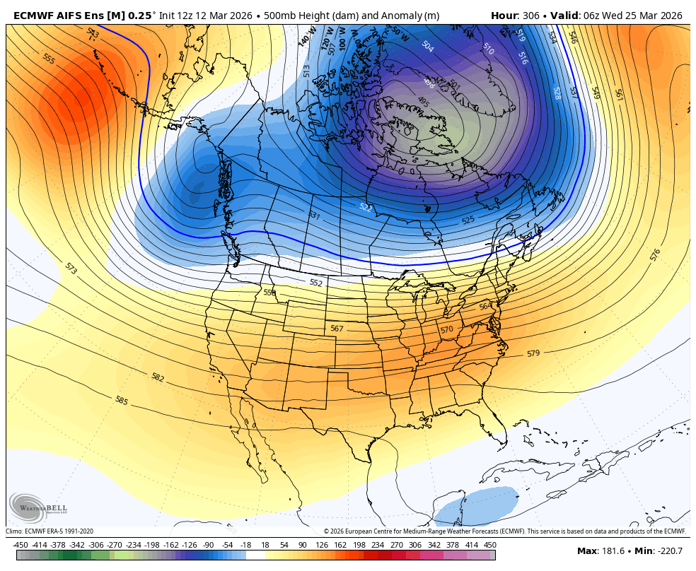
This pattern is much cooler for us in the Eastern Sierra, but does not really result in a solid storm window. It is however easier to get something clipping us out of this than when we have a giant heatdome overhead.
A winter of warmth
My friends... It is looking like spring came early this year, and the farther we get into March and April, the more likely it is that winter will permanently give way to the seasonal transition.
This makes it a good time to reflect on the winter, and dicsuss how it shapes up vs. my seasonal forecast.
First of all, this winter was the warmest on record out west, and March has been no exception to that. In my seasonal discussion from early Nov, I noted that this was a possibility, calling for above average temps out west. This was truly spectacular though, and far surpassed my expectations of a warm winter.
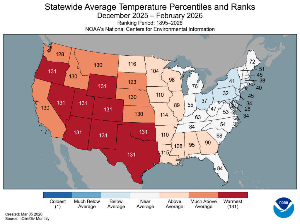
While snowpack numbers are a bit more dire, most of CA is near to above average in terms of precipitation.
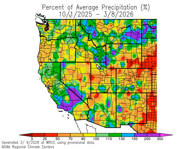
I also called for this in my seasonal discussion, noting that lower altitudes, especially Tahoe northward, would struggle to build snowpack due to high temperatures, but precipitation would be near to above average everywhere in CA.
This is all driven by frequent polar vortex disruptions, which disrupt the propagation of rossby waves, large-scale jetstream waves that drive mid-latitude weather patterns by causing areas of high and low pressure.
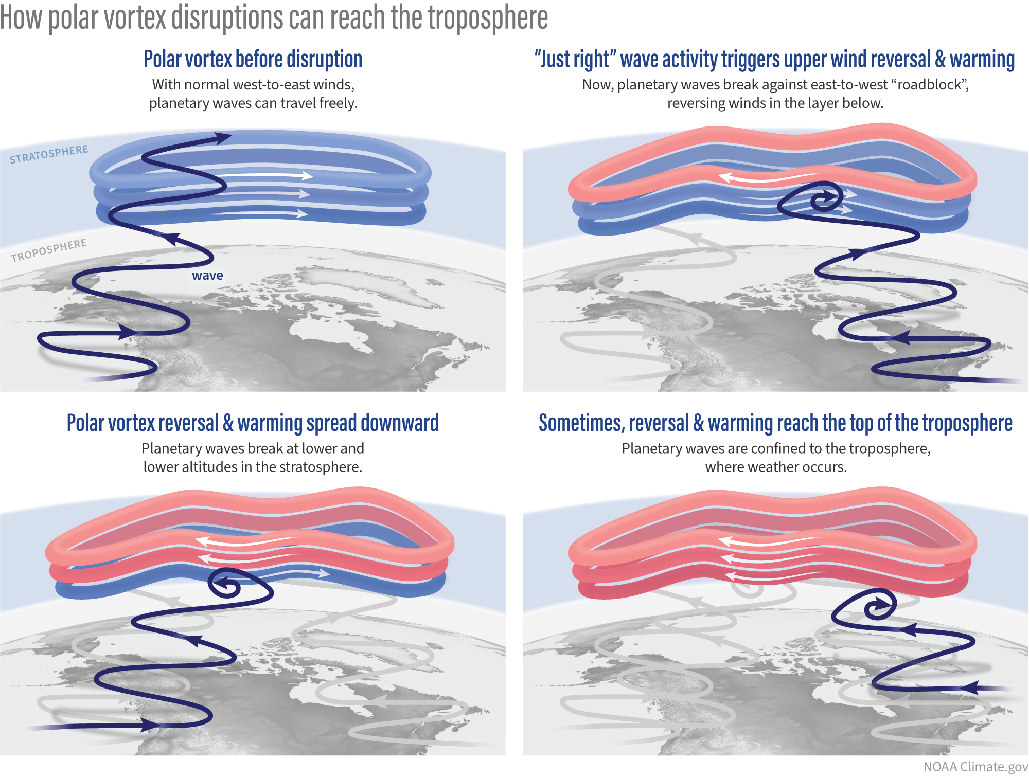
The polar vortex reflects its wave energy down to the troposphere, which disrupts the usual flow of rossby waves across the pacific, leading to highly stationary but amplified patterns.
This is why we have been seeing 30+ day ridges out west, while the east had an extreme winter.
However, every time the PV has relaxed, CA has gotten hammered. Again, not to toot my own horn, but I did identify this as a possibility in my winter outlook, stating that there was a possibility of "more frequent PV disruptions, trapping cold air out east" and that we would have "long dry periods punctuated by very impactful storms".
Now onto the parts where I was wrong...
I thought Mammoth would be able to build a bigger snowpack, but the scale and frequency of PV disruptions precluded that from happening. I called for a 400+" winter at Mammoth, and at 244", it seems very unlikely to happen at this point... So it goes!
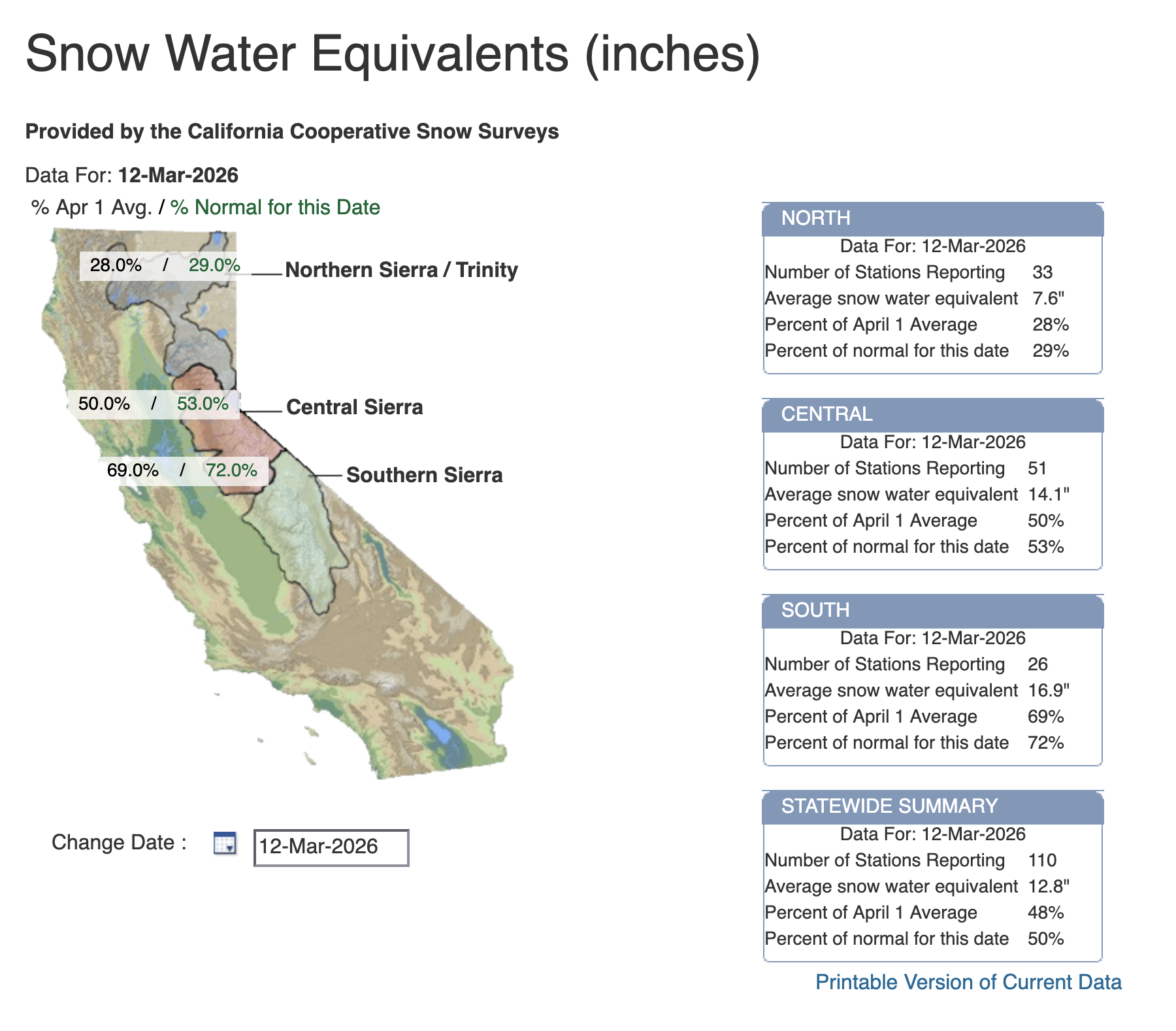
While the numbers in the southern Sierra are much more encouraging than farther north, with this ensuing heatwave, the numbers on the April 1st snow survey will probably reveal a bad situation everywhere for snowpack.
Hope the end of march into april has a change for us!