Our First Proper Winter Storm!
Overview
My friends...
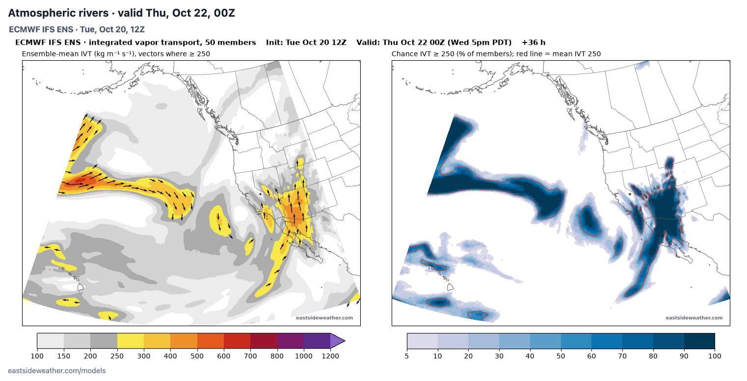
Our storm arrives on Wednesday evening and will last through Thursday. A cutoff low strengthening off the California coast is pulling a southerly plume of moisture into the Sierra. That southerly flow brings in warmer air, which means high snow levels that won't come crashing until early Thursday morning. It also means Mammoth is rain shadowed relative to other mountains nearby, so most of our moisture falls as Sierra Cement higher up and mostly rain in town.
The NWS in Reno has issued a Winter Weather Advisory for Mono County from 11 AM Wednesday to 5 PM Thursday! Our first of the season!
Longer range, another potential storm window is emerging for the very end of October, but confidence is still low this far out.
The storm...
The cutoff low is spinning off the central California coast tonight. As the low approaches CA, it is pulling a southerly plume of moisture towards the Sierra, with the heaviest precipitation arriving Wednesday evening into Wednesday night. Showers and a thunderstorm are possible as early as Wednesday afternoon.
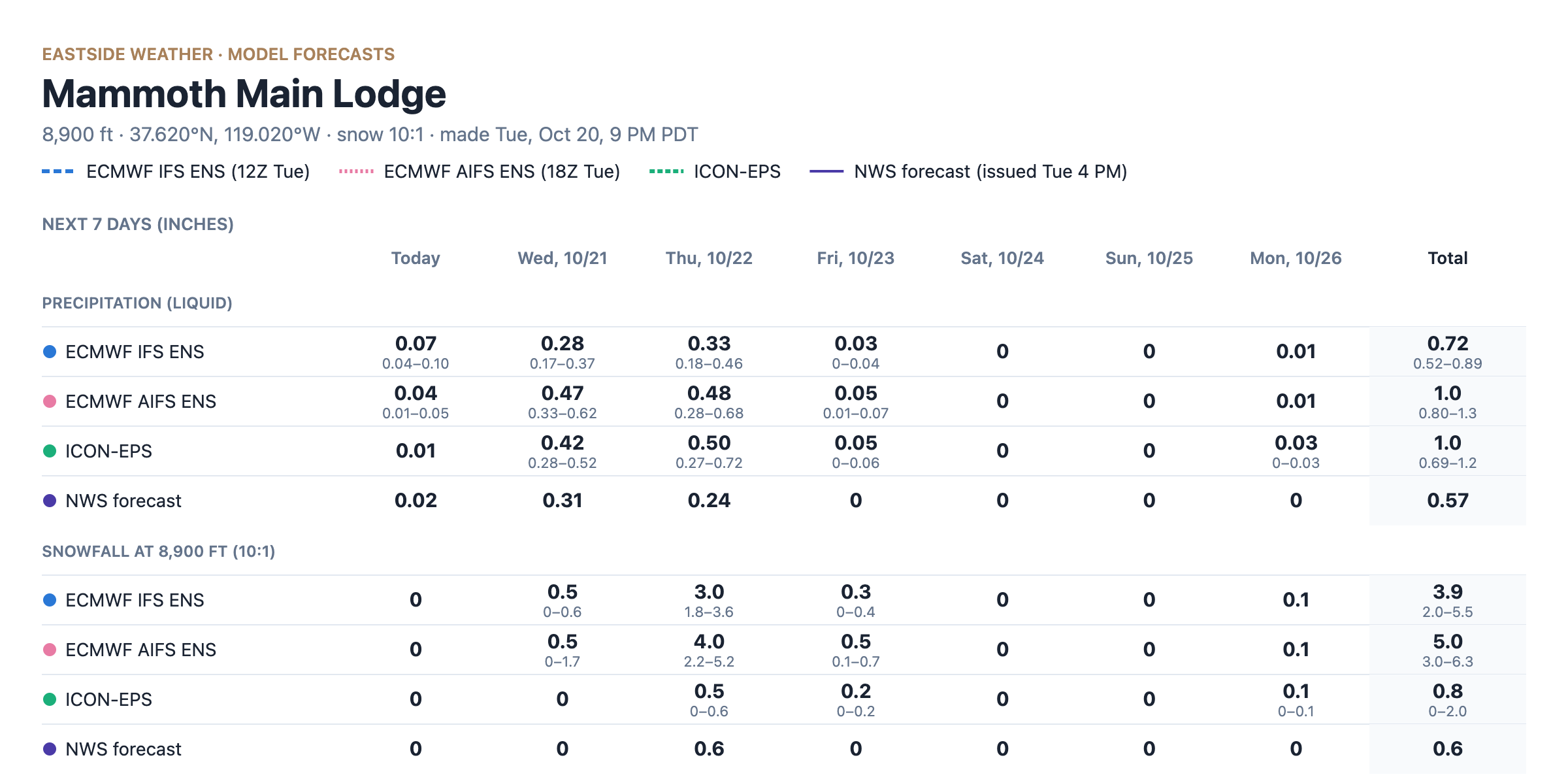
Southerly flow does not favor big totals in Mammoth. With moisture streaming up from the south, the high terrain of the southern Sierra rainshadows us, so Mammoth sees less than surrounding areas. The ensembles show around 0.6-1" of liquid at Main Lodge, with the Euro AI and Icon leading the charge.
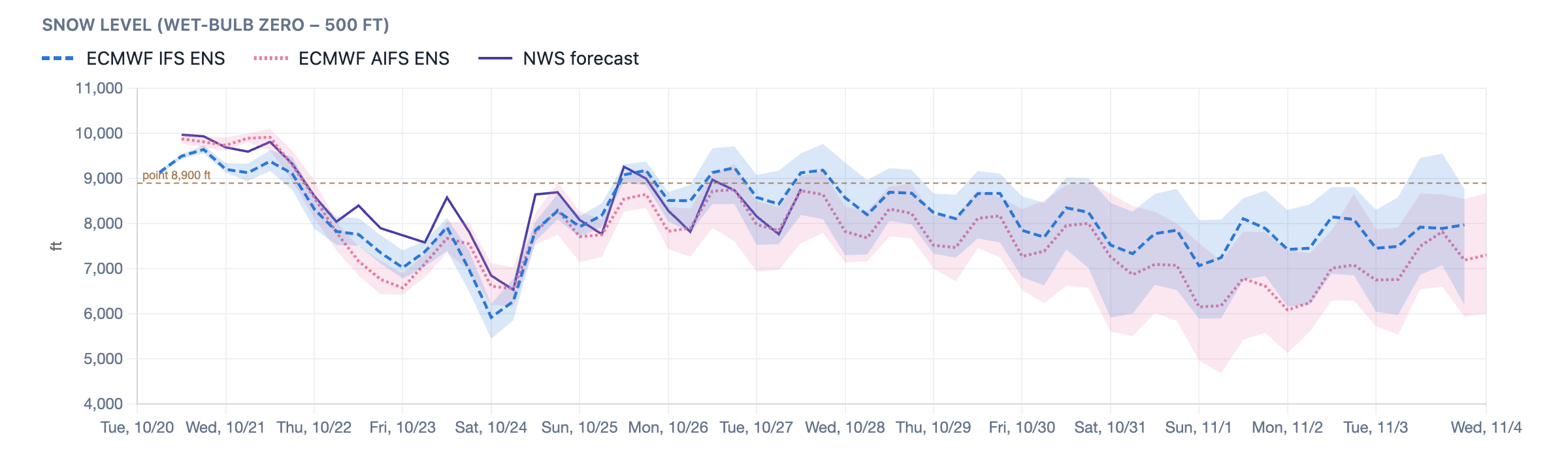
That southerly flow also means warmer air, which means a tough forecast due to marginal snow levels, and little snow to show for our storm down in town. Snow levels start out around 9,500 to 10,000 feet, during the heaviest precipitation Wednesday. Snow levels then come down overnight as the low moves inland, falling below Main Lodge and reaching right around the town level early Thursday morning. They continue to lower into Thursday evening as the last showers wind down... Late Wednesday into Thursday is when town will be right around the snow line, so we could actually see some sticking.
Here's the AIFS terrain-aware snowfall forecast for the storm, showing modest totals at higher elevations, and not much for the lower areas especially east of the crest.
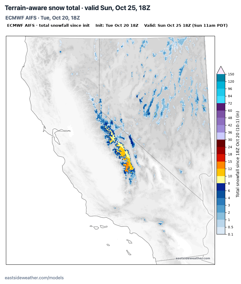
All in all, I'm expecting 4-8" of snow above 9,000 feet, with up to 10" possible along higher peaks, and 2-5" at Mammoth's Main Lodge. In town, the snow line will be marginal and fluctuate. If we see any accumulation, it'll be overnight Wednesday or Thursday night when we have colder air. We could see up to an inch sticking in town on the tail end of the storm, but it will mostly be falling as rain.
Showers clear out Thursday night, followed by a mostly sunny and cool Friday, and a sunny, warmer weekend.
Longer range
Longer range, models show a ridge building over the Gulf of Alaska with a trough digging down the West Coast around Halloween. This -EPO (East Pacific Oscillation) pattern (Alaskan ridge) means our storms are moisture starved and track dependent. Not the best setup to lock in a big storm, but that might arrive in November with a possible Gulf of Alaska trough.
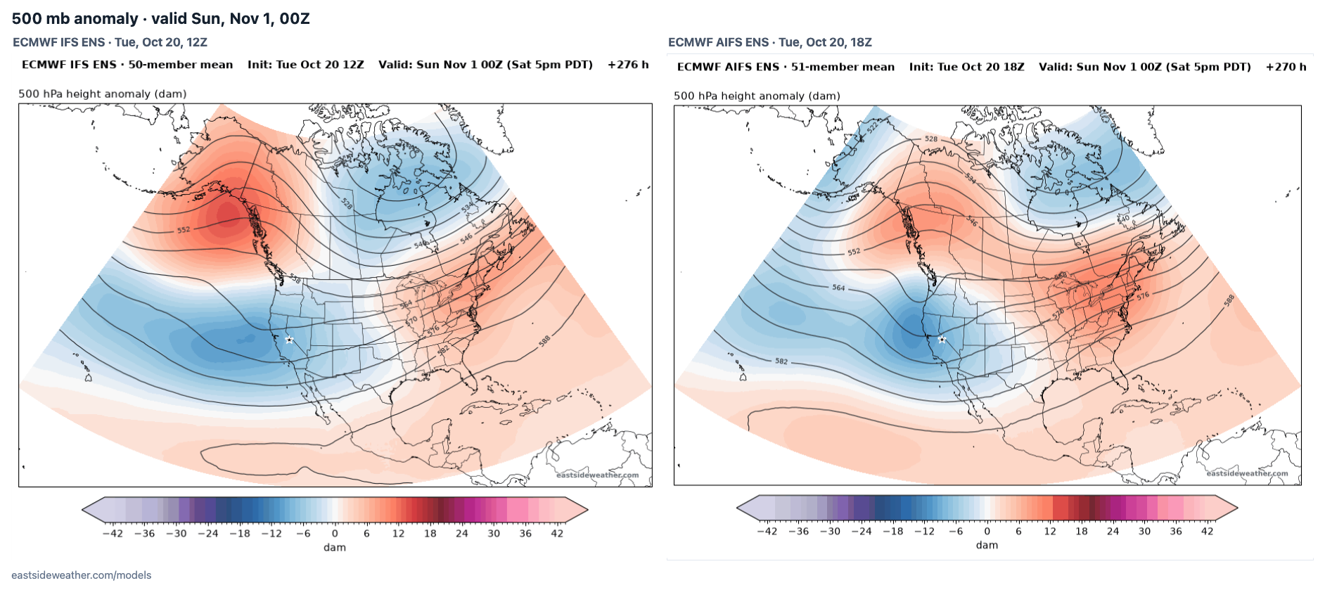
WeatherNext 3 shows the same window, with members starting to fan out around October 30. A handful of members bring another 1-3" of liquid to Mammoth Mountain, while many keep things light. I do think November will hold better chances for bigger storms.
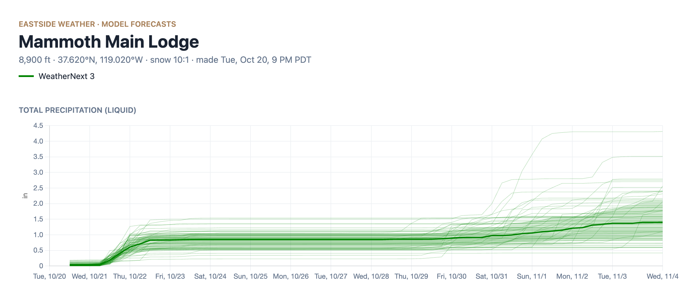
WeatherNext 3: © 2024-6 Google LLC, whose machine learning models were used to create the experimental data made available under the following licence terms https://storage.googleapis.com/weathernext-public/terms-of-use.pdf. This data is intended for experimental modelling only and is not intended, validated, or approved for real world use.
This is still pretty far out, so it's too soon to really discuss totals. Time will tell!
Enjoying the forecasts?
Eastside Weather is a passion project, but keeping it running comes with steady monthly costs: hosting, data feeds and the servers that crunch the model runs. Right now the site costs more than it brings in. Whatever you chip in goes straight back into keeping it going and building new tools.