Here Comes Winter! Storm This Week, More Activity Through November?
Overview
My friends...
Winter finally arrives in earnest this week with a more moderate storm. AI models have been trending stronger with this storm, while guidance is still split. The caveat to the stronger trend on AI models is higher snow levels. Uncertainty remains around the precipitation amounts, track, and timing of the storm, but as of now several inches of snow up to double digit totals is possible along the Sierra Crest and higher peaks, with a mix of mostly rain and some snow in the town of Mammoth Lakes.
After this, a much more favorable pattern for stronger storms is trending likelier as a Gulf of Alaska trough appears to be setting up. Uber long range modeling suggests this could stick around more often than not the entirety of November. This could be a canonical response to El Niño emerging, which would then be favored more often than not throughout winter per seasonal guidance and our dynamical understanding of strong El Niño events.
Storm This Week
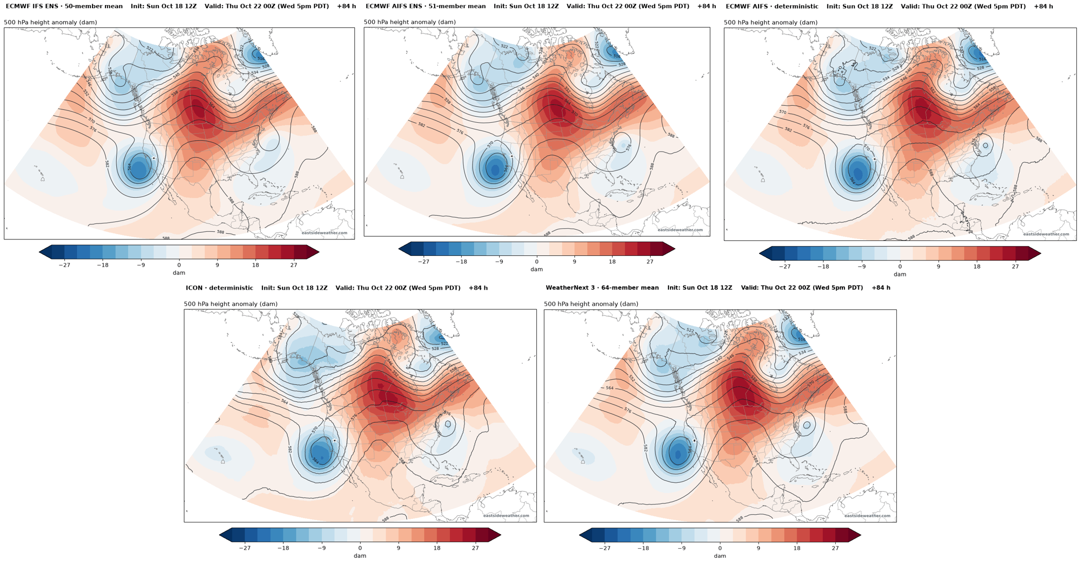
After a dry stretch, another cutoff low swings in from the Pacific on Wednesday. Models have seen this one coming for quite a while.
WeatherNext 3 data accessed through Google Cloud Storage. © 2024-6 Google LLC, whose machine learning models were used to create the experimental data made available under the following licence terms https://storage.googleapis.com/weathernext-public/terms-of-use.pdf. This data is intended for experimental modelling only and is not intended, validated, or approved for real world use.
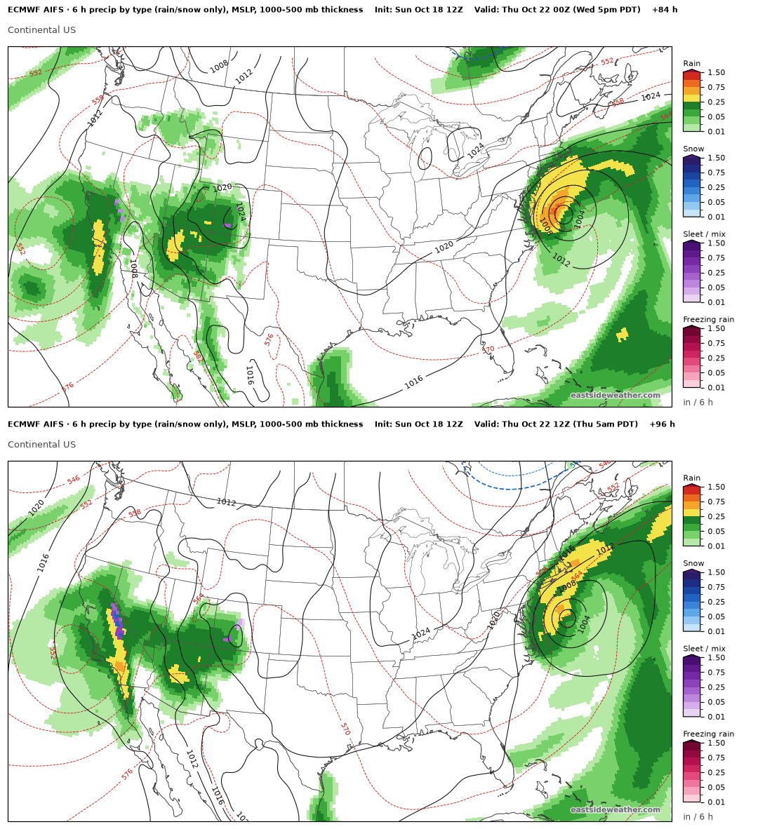
Unlike last week's low, this one is favored to stay offshore long enough to pull moisture in from the south before moving inland. That's good news for precipitation. The tradeoff is that it also pulls in mild subtropical air, so snow levels start out high. Over the past few runs, this storm has trended stronger, but also substantially warmer.
Precipitation looks to start Wednesday morning, with the heaviest rates Wednesday afternoon through Thursday, and lingering showers into Friday as colder air wraps in behind the low.
But How Much Snow??
Here are the precipitation percentiles through Thursday evening from the Euro ensemble (IFS) and the Euro AI ensemble (AIFS). The 10th percentile is the drier end of each ensemble, and the 90th is the wetter end:
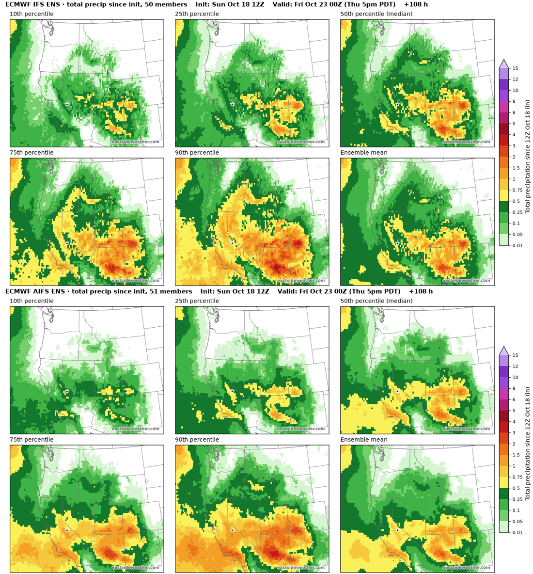
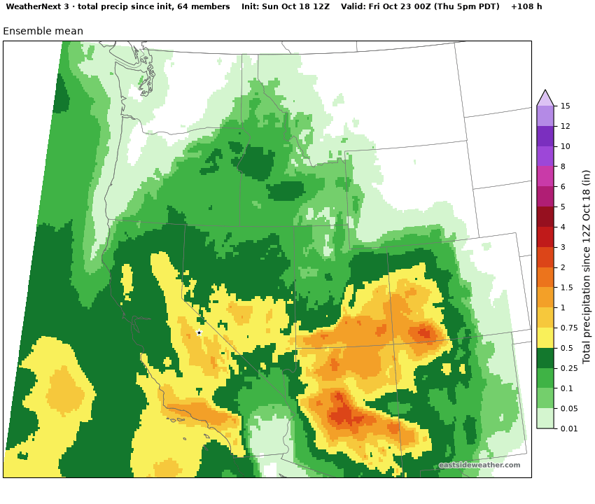
The Euro AI model is showing more moisture than the Euro dynamical and GFS models. WeatherNext 3 also is showing more moisture.
WeatherNext 3 data accessed through Google Cloud Storage. © 2024-6 Google LLC, whose machine learning models were used to create the experimental data made available under the following licence terms https://storage.googleapis.com/weathernext-public/terms-of-use.pdf. This data is intended for experimental modelling only and is not intended, validated, or approved for real world use.
Personally, I'm more inclined to believe the AI models here, which are favoring a slightly wetter and warmer storm.
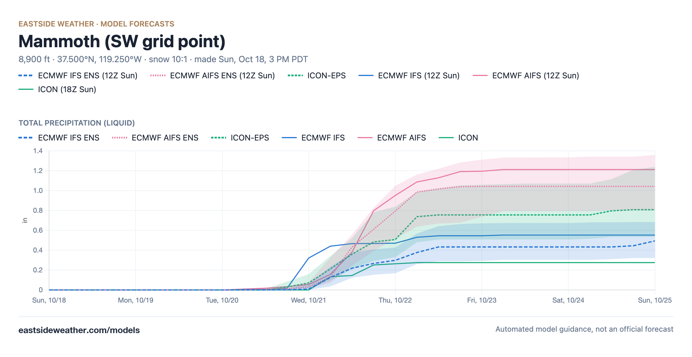
Here we can see the plumes from each model showing the spread of outcomes.
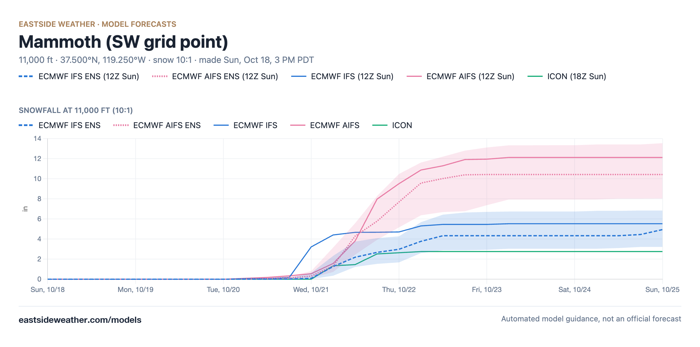
Up on the higher peaks, at 11,000 feet, the AI models bring about 10 to 12 inches of snow, while the Euro is closer to 4 or 5 inches:
QPF and Snow Levels
Precipitation (QPF). Models currently show a range of about 0.4-1.2" of liquid equivalent along the crest near Mammoth through Friday. The AI models sit on the higher end, around 0.7-1.2", while the IFS and ICON come in closer to 0.3-0.6". Leaning on the AI models, I'm expecting around 0.7-0.8" along the crest, with considerably less spilling over to the east. This storm is bringing in a strong southerly flow component, which means Mammoth Mountain may be rainshadowed here relative to other peaks.
The bulk of it falls Wednesday afternoon through Wednesday night, with lighter showers Thursday as the low moves through.
Snow levels.
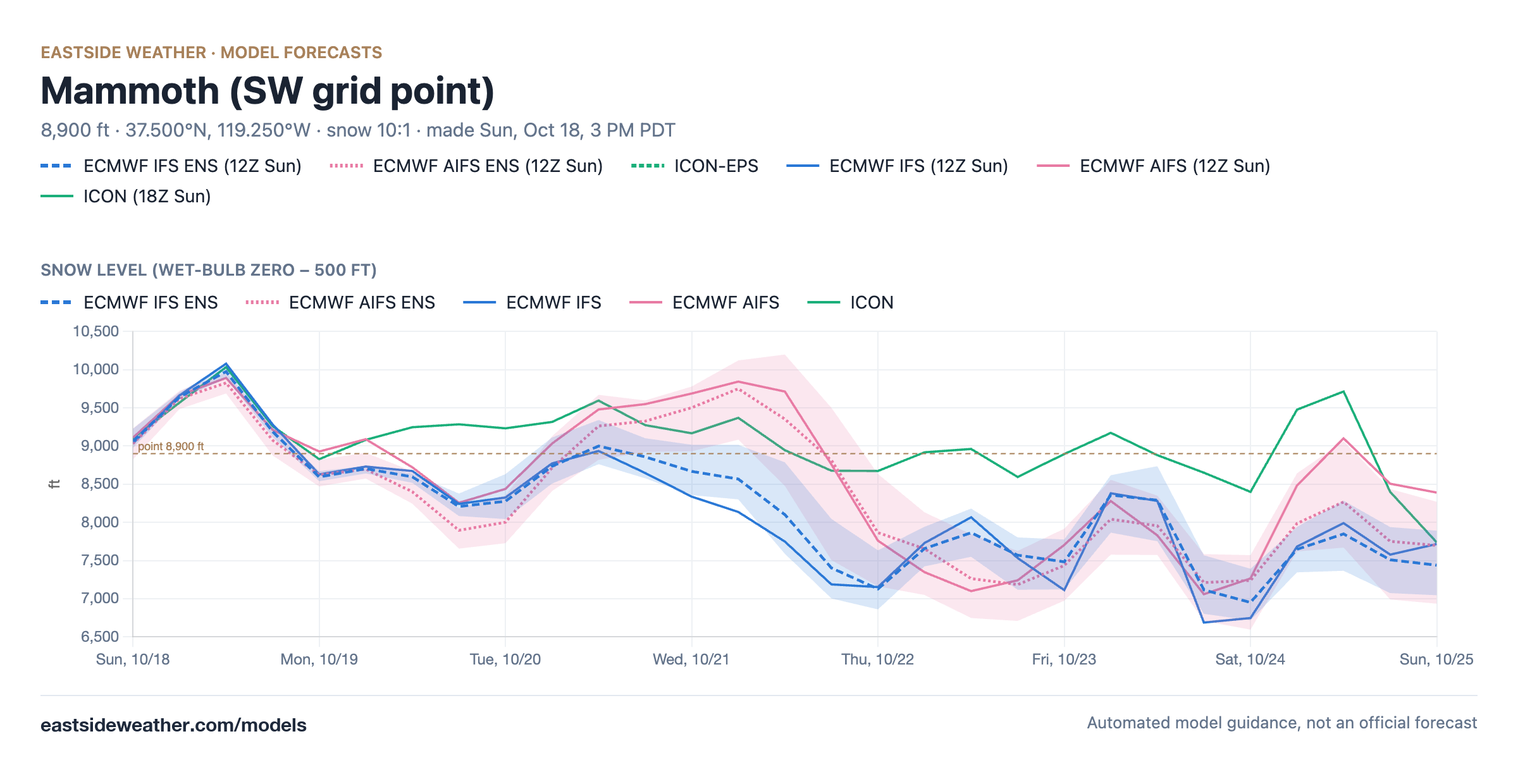
Snow levels will be roughly 9-9.5k during the heaviest precipitation Wednesday and Wednesday night, lowering to roughly 7-7.5k by Thursday morning as the colder air wraps in behind the low. Unfortunately, most of the QPF falls before the cold air arrives. A second, weaker wave late in the weekend also looks to come in with high snow levels, around 8-9k.
Wednesday appears to mostly rain main lodge and below, with only the highest peaks seeing snow. By Thursday morning, snow levels may come crashing below main lodge but the town of Mammoth Lakes is likely to remain marginal.
My Forecast for This Storm
Summit (11,053'): 5-9" of heavy, wet snow, with a range of 3-11". About 0.7-1.1" of liquid at around 8:1 overall. Sierra cement!
Main Lodge (8,900'): 1-5", with up to 7" possible. Rain or a rain and snow mix Wednesday, turning to snow overnight into Thursday as the snow level drops below 9k, at around 10:1. About 0.5-1.2" of liquid, much of it falling as rain.
Town of Mammoth Lakes (7,800'): 0-2", with up to 3" possible. Mostly rain, possibly ending as wet snow Thursday night. About 0.5-0.75" of liquid, less on the east side of town.
In total, I'm expecting about 5-9" of snowfall for the Sierra Crest near Mammoth, 1-5" at Main Lodge, 0-2" in town, and little to nothing along most of the 395 corridor. If the AI models are right, the upper end of these ranges is well within reach. If the warm air hangs around longer, totals below 9k will come in on the low end. Not enough to get the ski season going, but a great start! It's also still a few days out and subject to change.
A Gulf of Alaska Trough, and Our El Niño Winter Getting Started Early?
After this storm, the pattern starts to shift. By early November, both ensembles build a trough over the Gulf of Alaska and the northeast Pacific, with the jet aimed more directly at the West Coast:
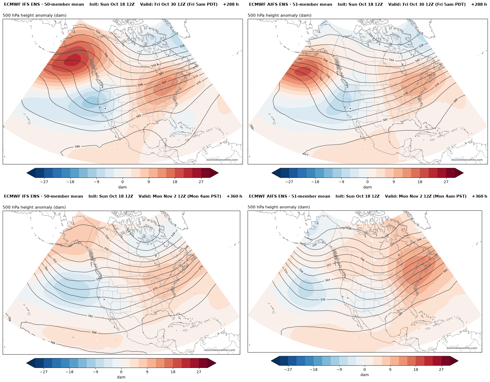
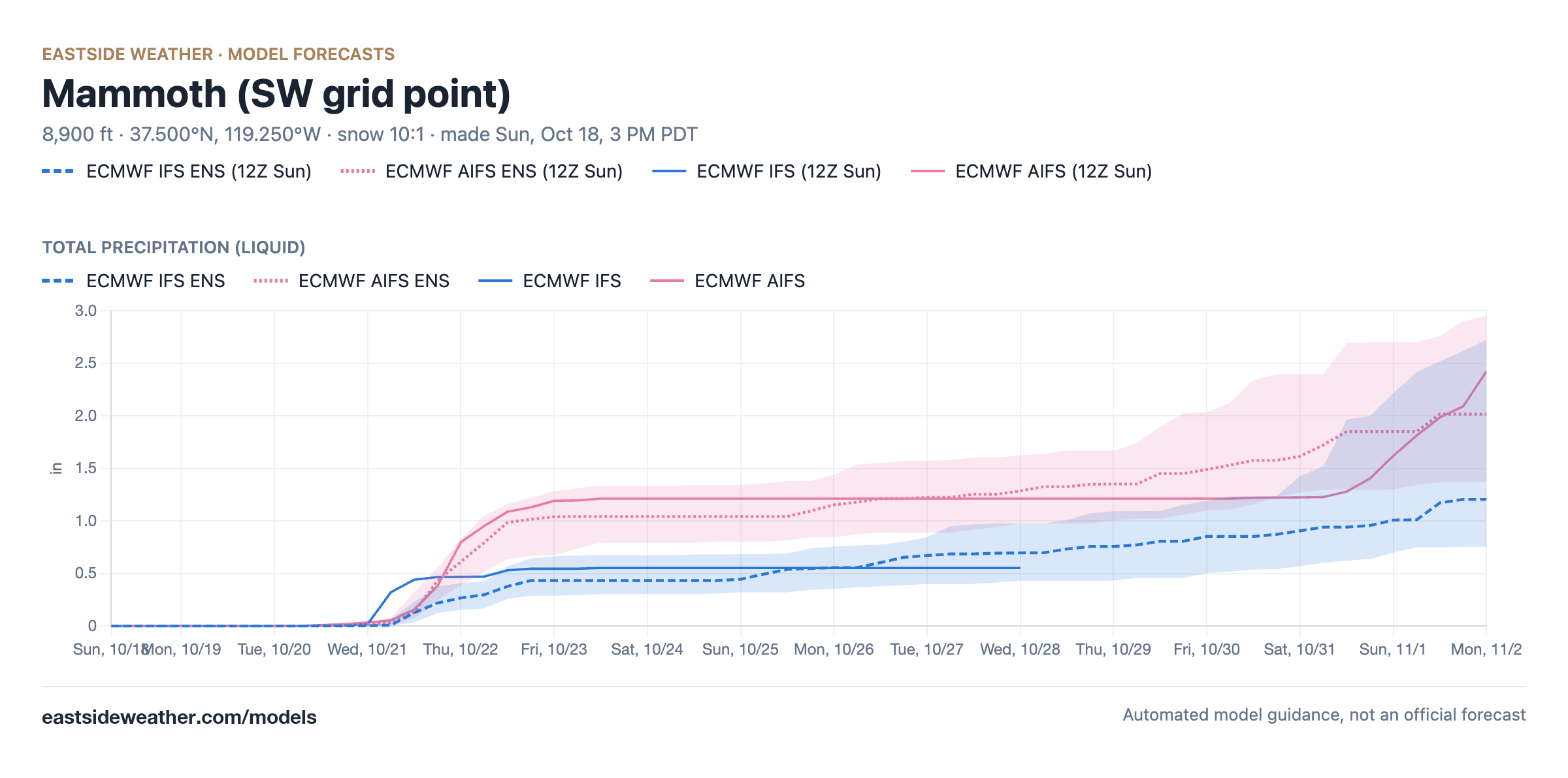
The plumes keep building precipitation into early November, with the AIFS ensemble averaging about 2 inches of liquid through November 2 and the IFS ensemble about 1.2 inches. The operational AIFS ends its run with a stronger storm right around November 1st... Something to watch!
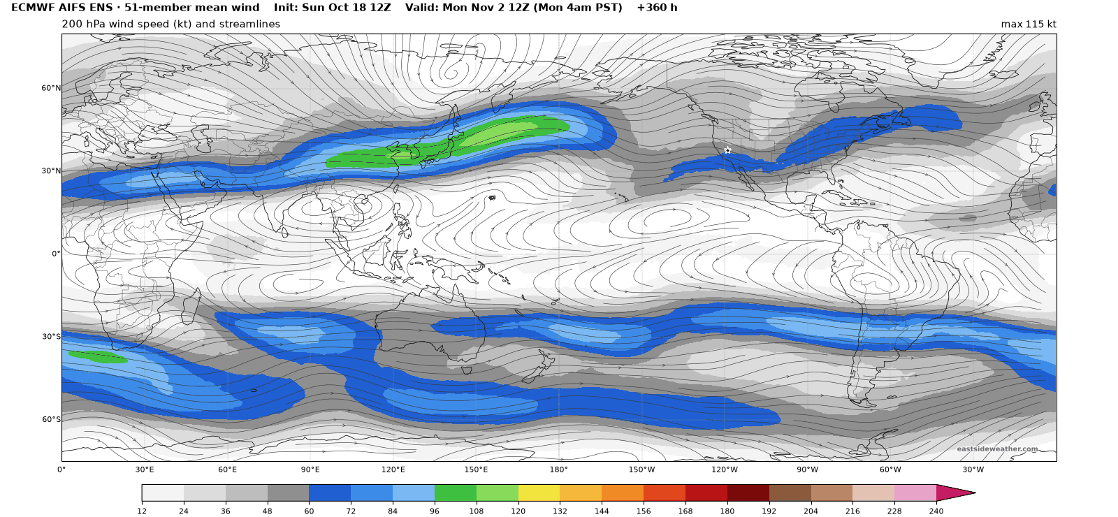
The jet stream tells the same story. Here is the 200 mb wind from the AIFS ensemble on day 15. Even in the mean of all 51 members, there's a distinct southern branch of the jet aimed straight at California:
And the ECMWF weeklies from today's run keep that trough parked in the Gulf of Alaska for the entire month, from November 3 through December 3, with a strong ridge over central Canada and a wetter than normal signal across California and the Sierra:
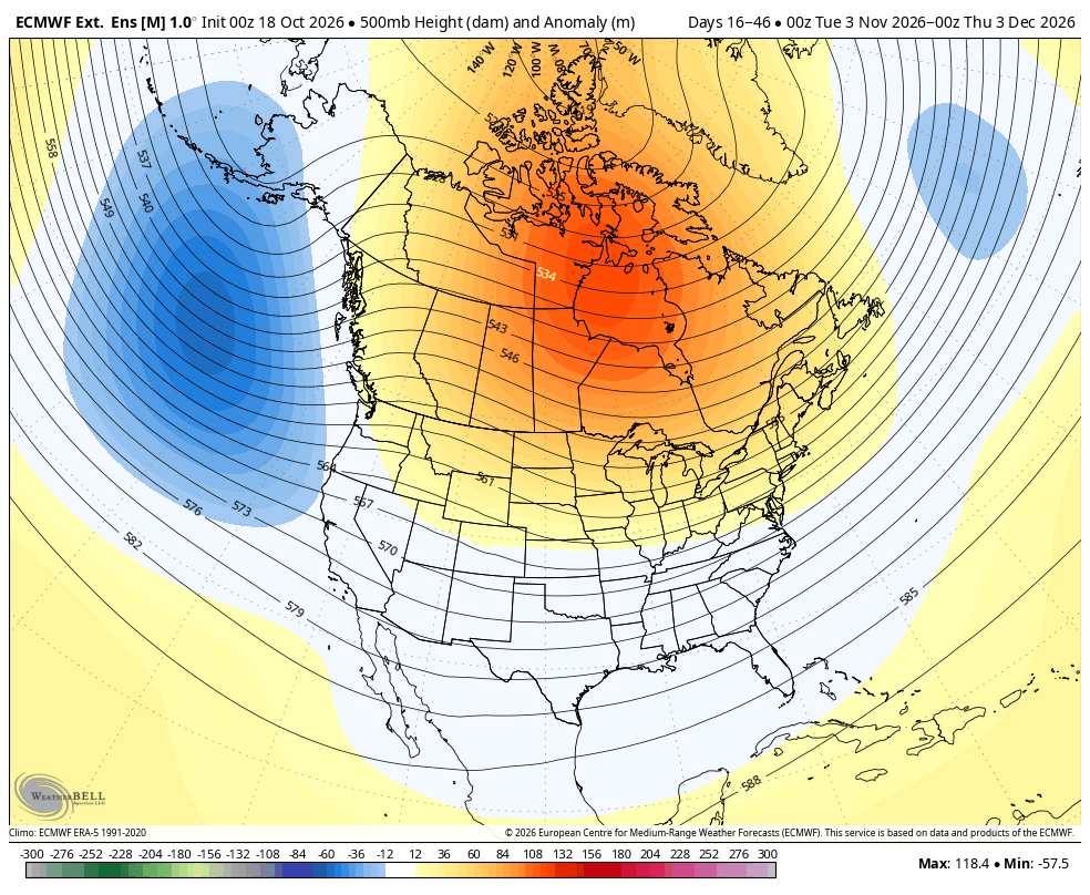
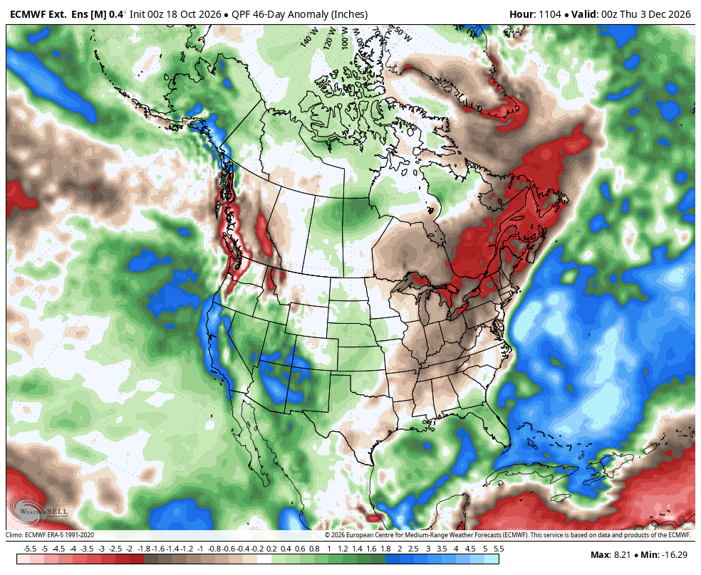
Images: WeatherBell Analytics, ECMWF data.
This is quite a strong signal and it's been showing up consistently across all models for quite some time. And this is the canonical El Niño look, so seeing this on models is also supported by our intuitive understanding. It's the same pattern the seasonal models show for our winter:
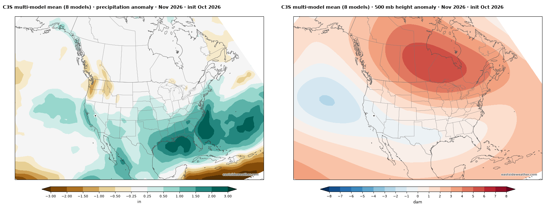
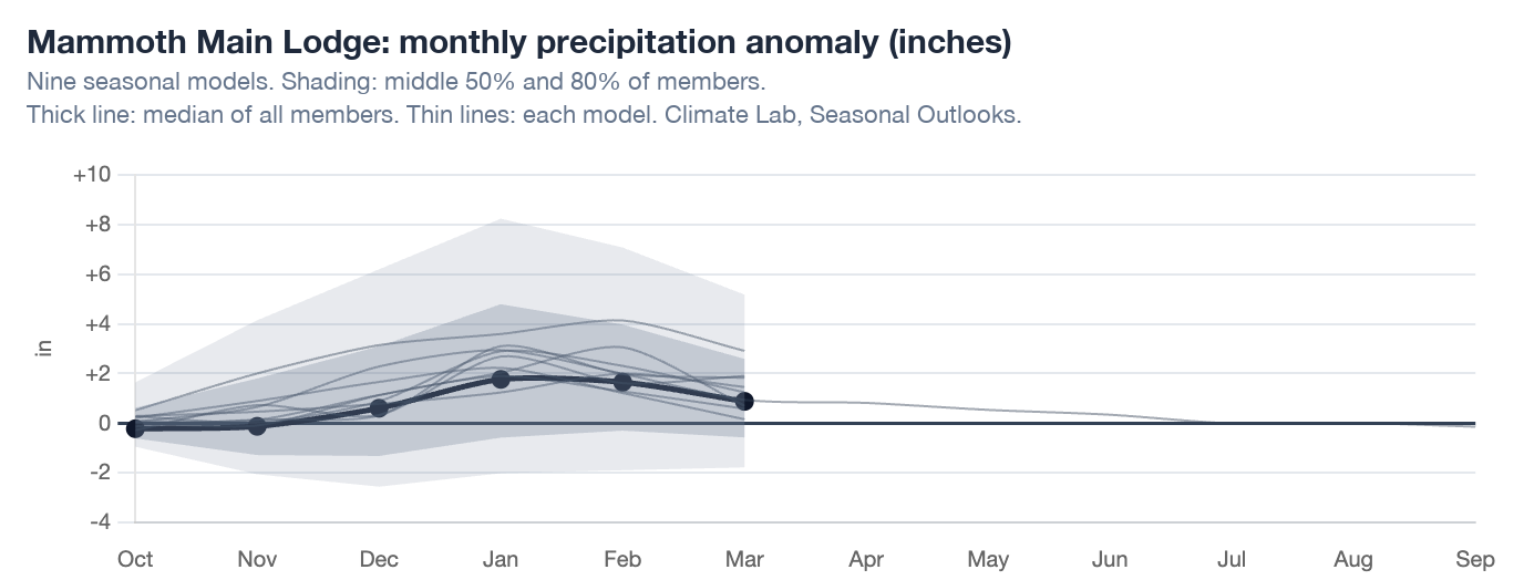
Usually, the El Niño response is backloaded towards January and February. The seasonal models show this backloaded response still being favored, but with a wet signal now emerging for November, I'm inclined to believe we start up sooner.
This El Niño is so far beyond any previous event in history. 1997-98 was the last historically strong east-based event, and the gold standard for what an "east-based" event looks like. This year, the Indo-Pacific Warm Pool (IPWP) sits a full 15 degrees of longitude farther east than in 1997-98. That's over 1,000 miles!
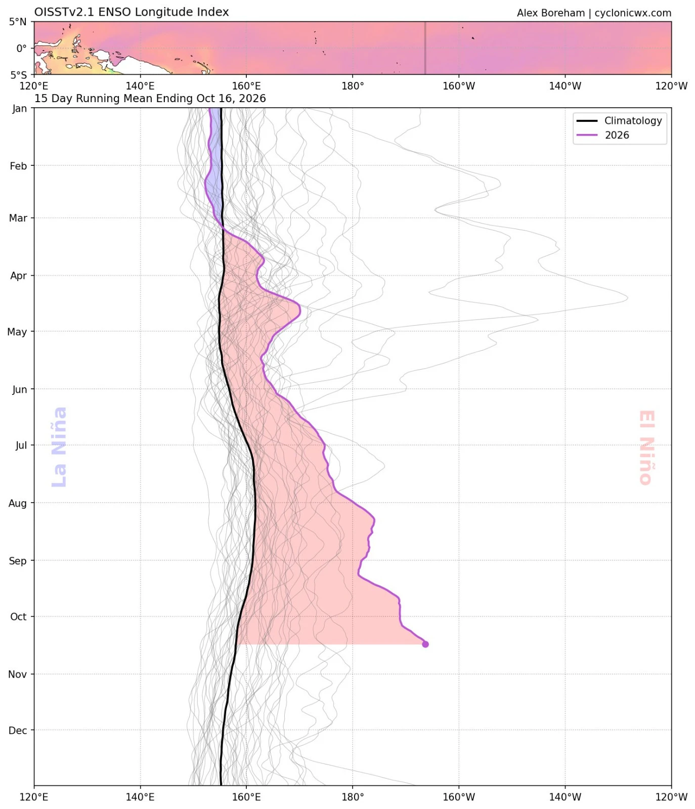
Image: Alex Boreham, cyclonicwx.com.
The farther east the IPWP shifts, the stronger the Subtropical Jet response should be across the eastern pacific into California. It blows the last event out of the water. I do really think the effects of El Niño will be felt profoundly starting in November, and throughout the winter. In my opinion, this is the climate event of the century!
The Season Ahead
Every single seasonal model shows a profoundly wet outlook for California. We've simply never seen this level of agreement. At Mammoth, the median of all members comes in at about 41 inches of precipitation through early May, against a normal of about 29 inches, or 143% of normal. And I believe this is underplaying the local impact in Mammoth. San Francisco shows 180%+ of average.
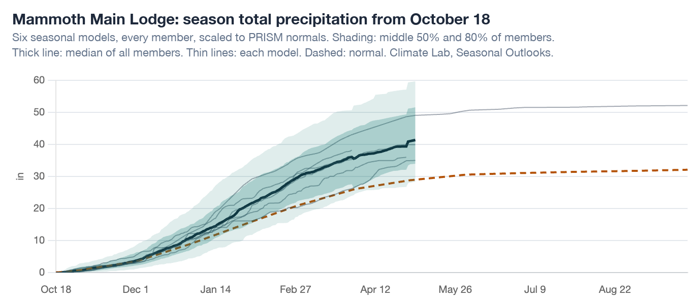
The odds are stacked incredibly so towards a wet and wild winter in California, both in the modeling and in our understanding of the climate. While there's always a chance it doesn't happen, I would be a fool to forecast anything different. I have almost no more doubts about the coming winter.
The one thing to watch, as this week's storm shows, is temperature. The seasonal models lean warm early in the season, and warm, juicy storms can mean rain down low and snow up high.
You can explore all of this on my Seasonal Outlooks page in the Climate Lab.
Winter is knocking on the door, my friends. My full seasonal outlook is coming soon... Until then, pray for snow! As always!