Our First Major Winter Storm Is On The Way! 30-40 Inches For Mammoth
Overview
My friends...
Apologies for the lack of updates over the weekend, I was out of town and not able to use my computer.
Friday's storm dropped over 1.6" of liquid and 9" of snow at Main Lodge. My snowfall forecast of 6-10" at Main Lodge and up to 15" higher up verified, as Mammoth Mountain reported 9-13" of Sierra Cement. However, the liquid came in well above the 0.85-1.15" most models showed. An overperformer on liquid that delivered great base building snow. I mentioned the HRRR outlier showing 1.5"+ of liquid, dismissing it as overdoing post-frontal convection. Now, I can eat my words and HRRR can say I told you so.
Today's storm also overperformed, with around 6" of new snow from around 0.7" of liquid as of this evening, well above the 0.25-0.4" most models showed before the storm. I doubt anyone is complaining about the extra liquid!
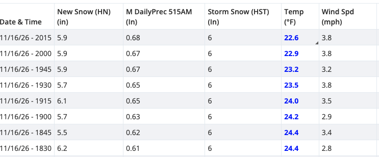
Data: Mammoth Mountain.
Now, our first major storm approaches. A potent closed low passes right over California Wednesday into Thursday, bringing very heavy snow to the Sierra above 5,000 feet. Ensembles show around 3-4" of liquid at Main Lodge, and after two storms in a row came in wetter than modeled, I wouldn't be surprised to see this one overperform too.
For those who just want the numbers for Wednesday & Thursday: I'm expecting 30-40" of snow at Main Lodge, 3-4 feet at the summit, and 20-30" in the town of Mammoth Lakes.
Wednesday & Thursday: a closed low right over California
Here is WeatherNext 3 early Thursday morning, which has been consistent in showing a deep closed low over the state of California, and now has support from other ensembles. WN3 for the win!
A closed cold core low passing right over the state is the best way to get big snow down to mid and lower elevations. A beautiful thing to see in November!
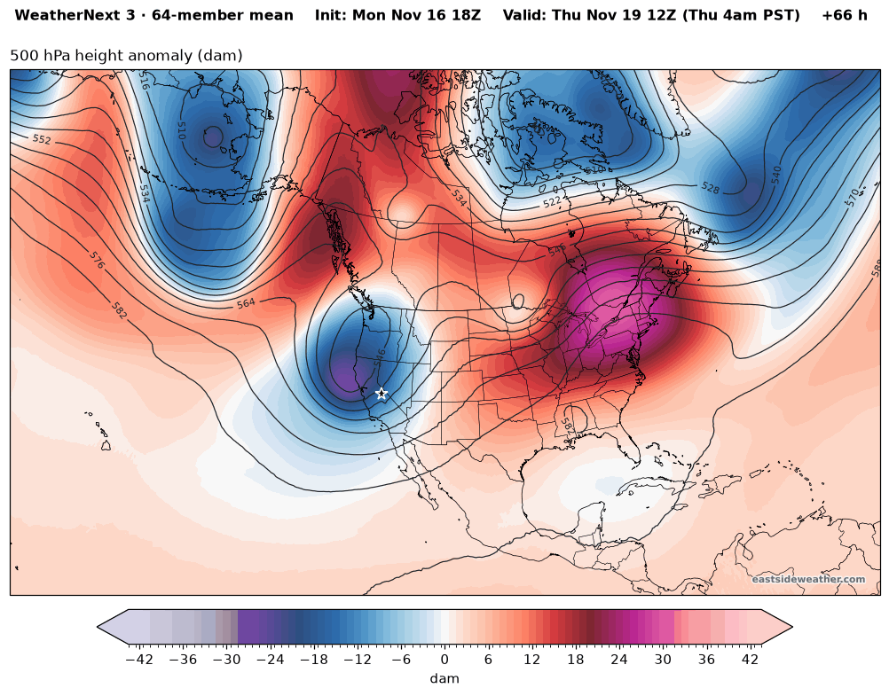
WeatherNext 3: © 2024-6 Google LLC, whose machine learning models were used to create the experimental data made available under the following licence terms https://storage.googleapis.com/weathernext-public/terms-of-use.pdf. This data is intended for experimental modelling only and is not intended, validated, or approved for real world use.
Strong frontal dynamics Wednesday give way to the cold core of the low Thursday, for a long period of heavy snow. This is a great storm by mid-winter standards, let alone November when our entire monthly average is only 26" at Main Lodge.
Snow levels
Snow levels start around 4,000-5,000 feet Wednesday (the ICON is warmer, at 6,000-7,000 feet), then crash to around 3,000 feet by Thursday night as the cold core moves right overhead. Once the coldest air moves in on the weaker tail end of the storm, snow could be possible down in the Owens Valley!
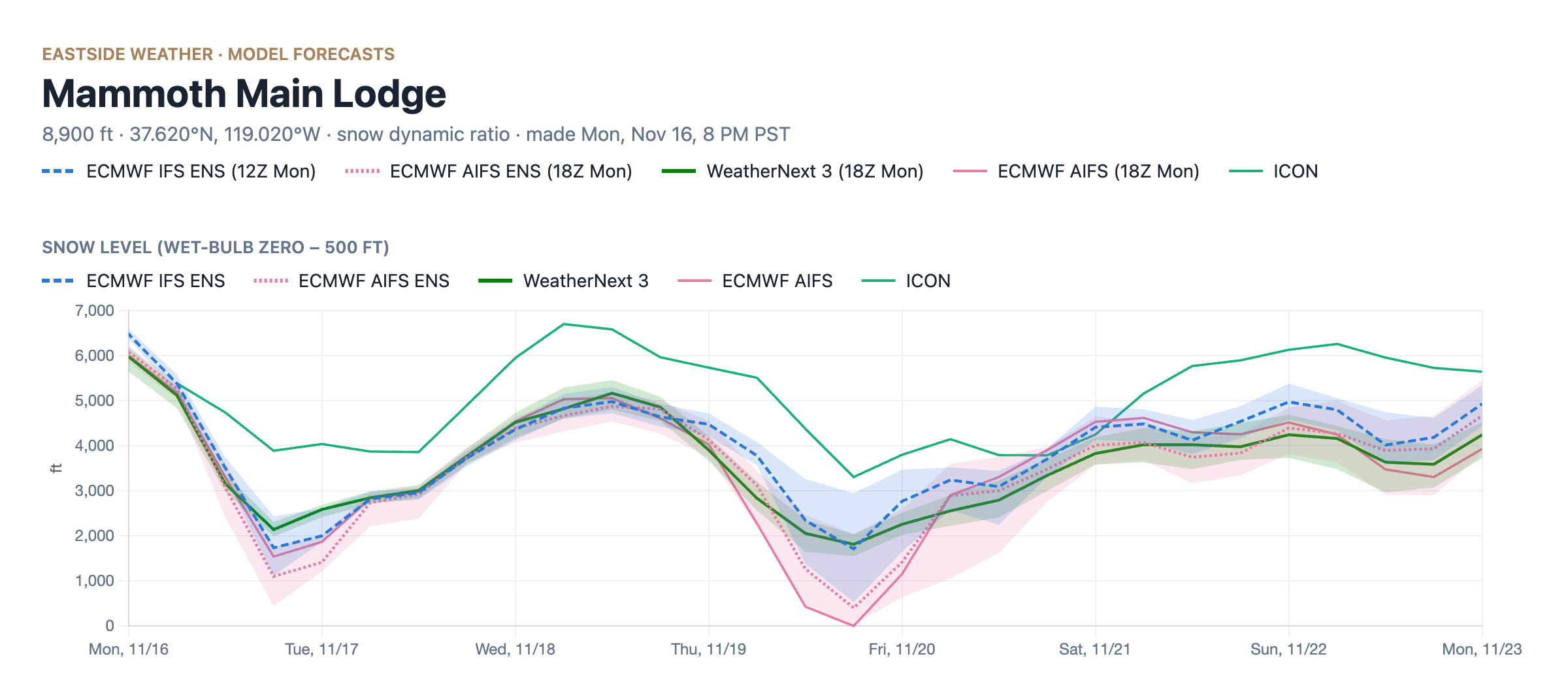
The colder air should lend itself to lighter snow than our last few storms.
Winds
As is typical in our region, this storm will bring a sizeable portion of wind along with it. The NWS in Reno is calling for ridgetop gusts as high as 100 mph in Mono County, with possible damage to trees and power lines and whiteouts at times. Expect blowing snow, wind holds on the upper mountain, and whiteouts along 395. This will likely make travel difficult to impossible for a large stretch of the storm.
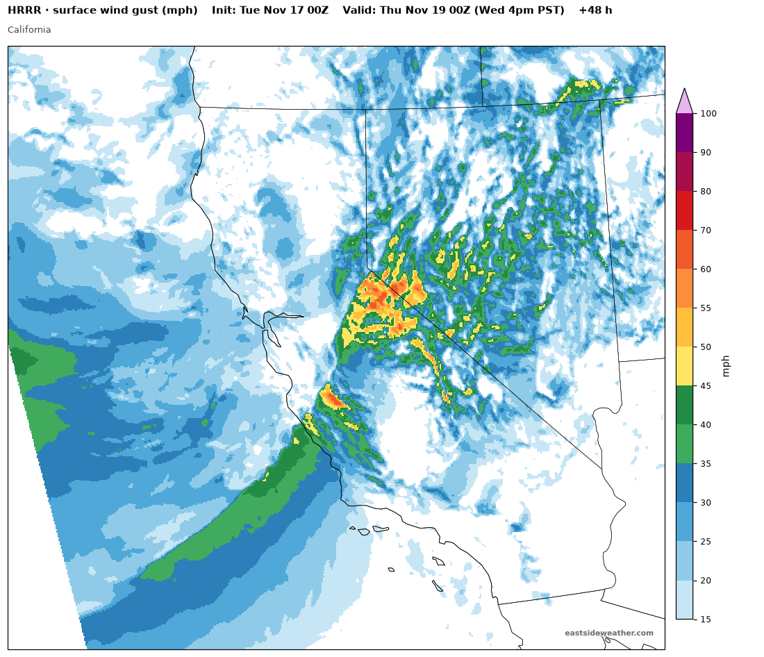
The wind also drags down the snow ratio. On paper, the colder air should allow for much higher snow ratios, but I'm not expecting much over 10:1-12:1, except for during lulls in winds.
How much snow?
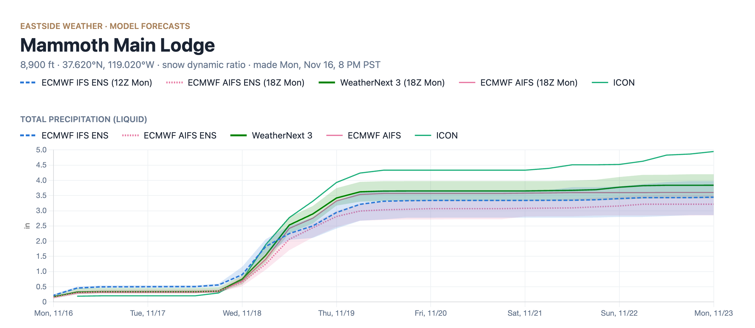
Ensembles show Main Lodge median precipitation totals of 3.2" for the AIFS ENS, 3.4" for the IFS ENS, and 3.8" for WeatherNext 3, with the AIFS at 3.6" and the ICON wettest at 4.3". A majority of that falls on Wednesday into Thursday AM.
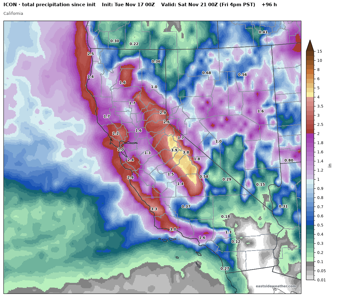
The ICON puts 3.5-4"+ along the crest from Yosemite down past Mammoth.
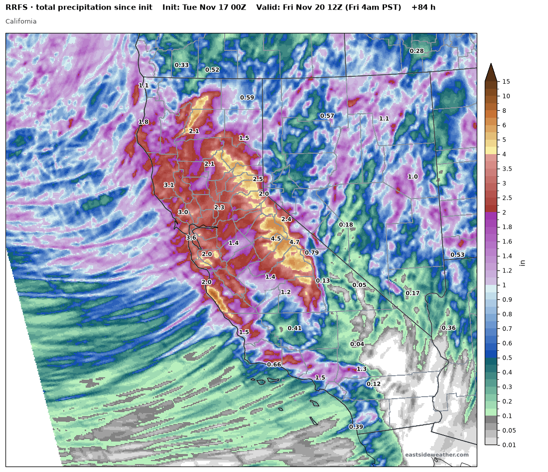
It's worth mentioning the RRFS outlier, and waiting until the HRRR gets into view, considering the overperformance of the last two systems. The RRFS shows 5.5" of liquid around Mammoth. We'll see what HRRR shows tomorrow evening. Could be a barn burner!
Record warm water off the coast
The ocean off California is extremely warm right now, with sea surface temperatures 4-7°C (7-12°F) above normal along coastal California.
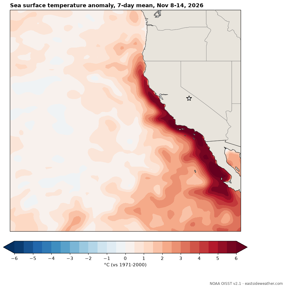
Warmer water puts more moisture into the air that feeds our storms, and makes the lower atmosphere more unstable as storms come ashore. More moisture plus more lift means more precipitation...
Models may not fully capture this. Some use a slowly updating or smoothed ocean temperature field, and the AI models learned from a climate that rarely saw water this warm off our coast. That could be part of why our last two storms came in wetter than modeled. El Niño has created a historic coastal heatwave in California, which could add meaningful additional moisture to any storms all season long.
Putting it all together
Given a range of 3-4" of liquid, pending the HRRR, I'm expecting the following snow totals:
- Main Lodge: 30-40"
- Summit of Mammoth Mountain and higher peaks: 3-4 feet
- Town of Mammoth Lakes: 20-30"
Travel Wednesday and Thursday will likely be very difficult to impossible at times, so plan ahead! Please be prepared and be patient as the mountain may have significant delays.
The extended range: the Gulf of Alaska trough stays planted
Another storm could be right behind this one. Here is WeatherNext 3 for the day before Thanksgiving, with a deep trough still parked in the Gulf of Alaska.
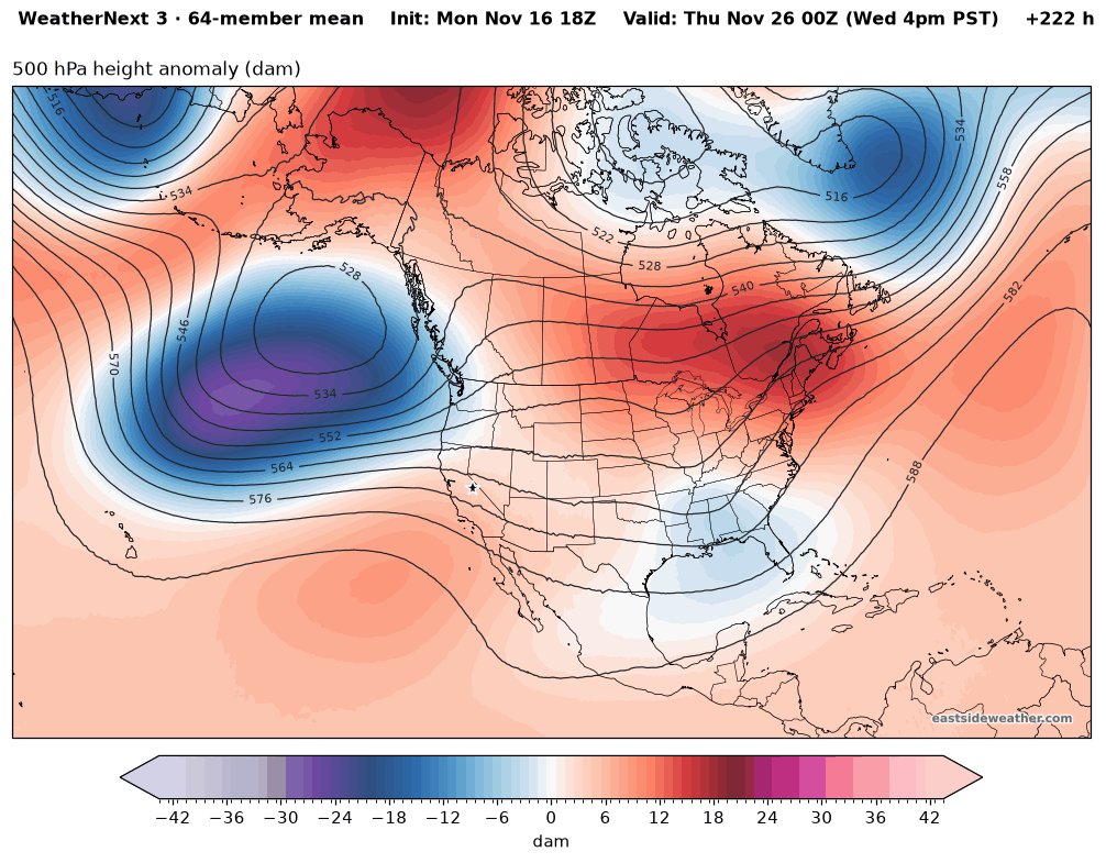
As long as that trough stays planted, the storm door stays open, and storm chances continue for the foreseeable future. It is getting real my friends... Here we go!
Recap
- Friday's storm: over 1.6" of liquid and 9" of snow at Main Lodge. The snow forecast held, the liquid overperformed.
- Today's storm: around 6" of snow from around 0.7" of liquid, also wetter than modeled.
- Wednesday into Thursday: our first major winter storm. 30-40" at Main Lodge, 3-4 feet on the summit, 20-30" in Mammoth Lakes. Ridgetop gusts as high as 100 mph keep the snow ratio around 10:1-12:1.
- Beyond: the Gulf of Alaska trough stays planted, and so do our storm chances.
Let it snow!
-Noé Barrell
Enjoying the forecasts?
Eastside Weather is a passion project, but keeping it running comes with steady monthly costs: hosting, data feeds and the servers that crunch the model runs. Right now the site costs more than it brings in. Whatever you chip in goes straight back into keeping it going and building new tools.