Storm Day! Wind, Heavy Snow, And A Wetter Storm Trending For Next Week
Overview
My friends...
We've been tracking this storm window for a while now, and it's arriving as I write this.
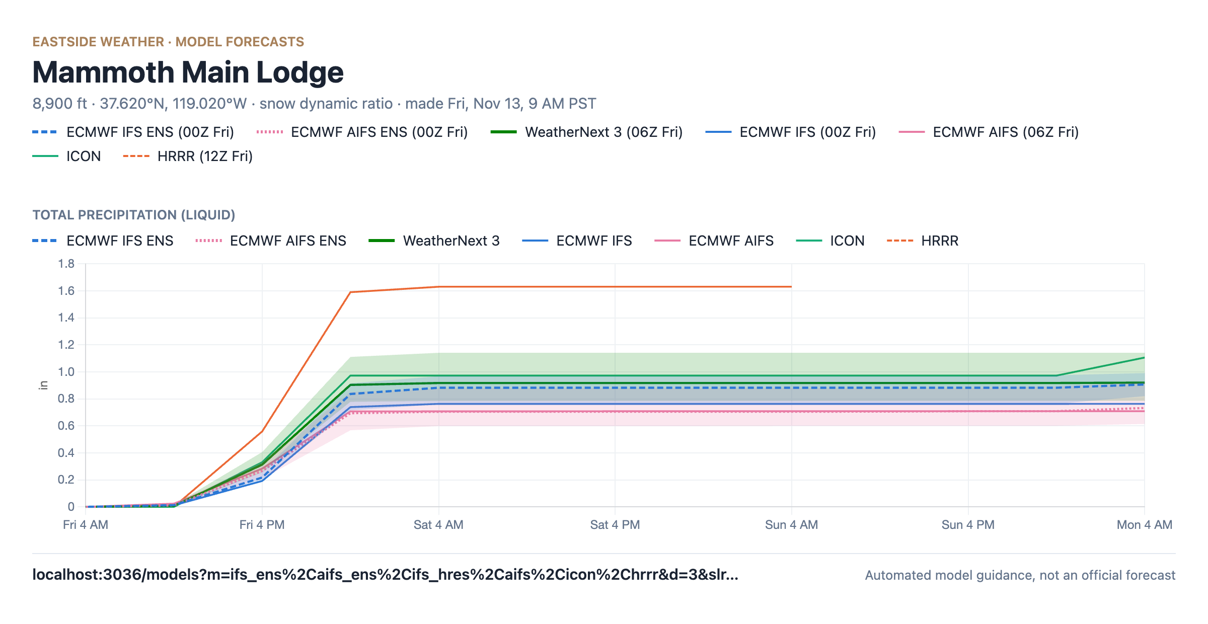
Models are showing a range of 0.85-1.15" of liquid for Mammoth Mountain and the surrounding Crest. One outlier is the HRRR model, which can often overdo post-frontal convection for us. Since it's an outlier, I'm not expecting the 1.5"+ of liquid it shows, but if we do end up getting that much, I suppose the HRRR can say I told you so. This one comes in warm, with snow levels around 7000 feet, and with very heavy winds coupling down to 395. This means Sierra Cement. A colder and drier system is on its heels Sunday night thru Monday, bringing another 2-4" of snow. And next week, we are still tracking a potentially much wetter storm for Wednesday and Thursday, although confidence remains lower around that.
For those who just want the numbers for Friday & Saturday: I'm expecting 6-10" of snow at Main Lodge, 4-7" in the town of Mammoth Lakes, and up to 15" on the higher peaks like the summit of Mammoth Mountain.
For Sunday and Monday: 1-3" of snow for Mammoth Lakes, 2-4" of snow at Main Lodge, and 3-5" at higher peaks.
Friday: a foot of snow and several feet of wind
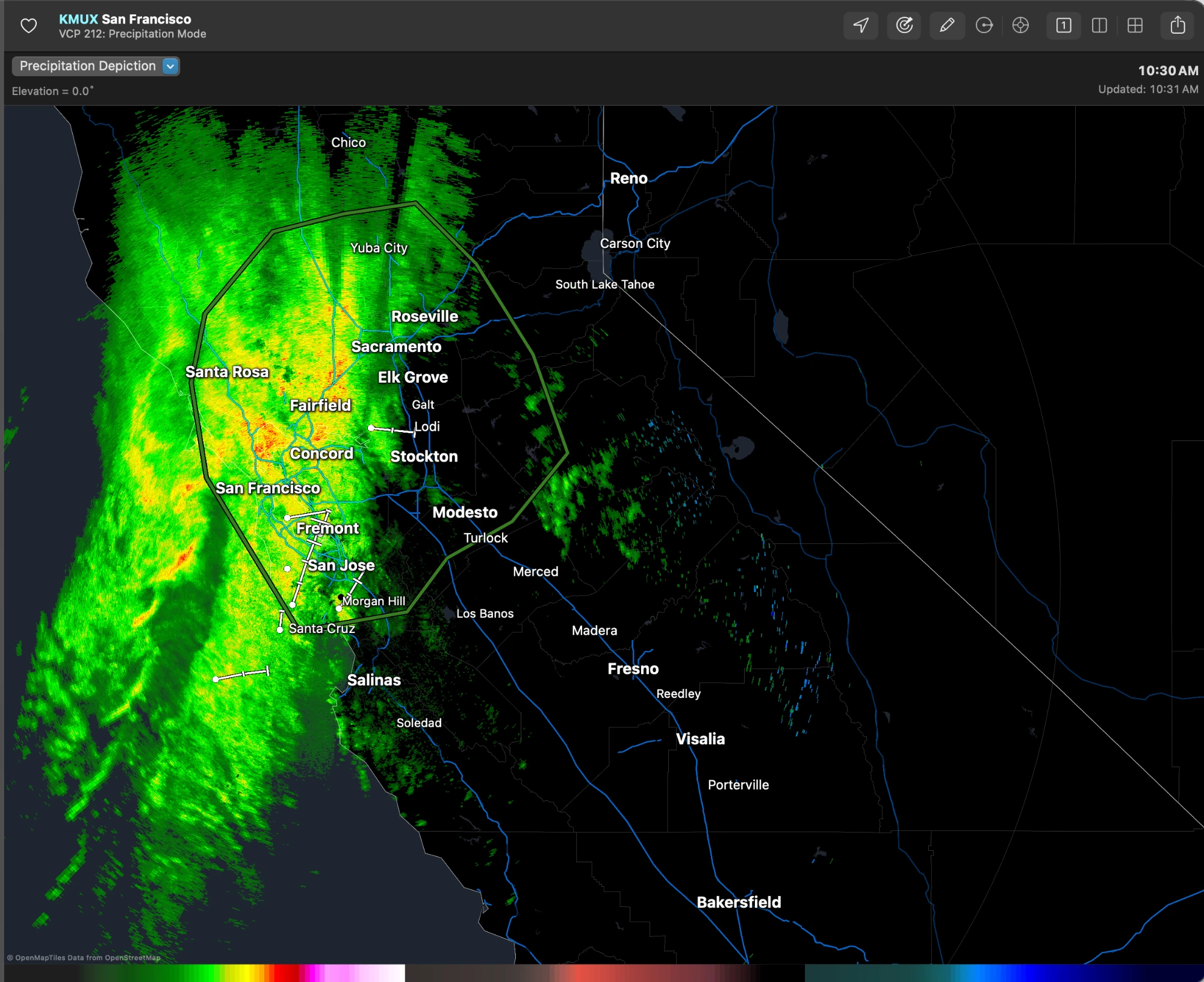
As of 11 AM Friday, the front has arrived along the coast of California and is pushing inland. Here's the San Francisco radar, showing moderate to heavy rain from Santa Rosa and Sacramento down through the Bay Area to Santa Cruz, and the first showers already reaching the Sierra foothills east of Stockton and Modesto. That band will push into the Central Sierra this afternoon.
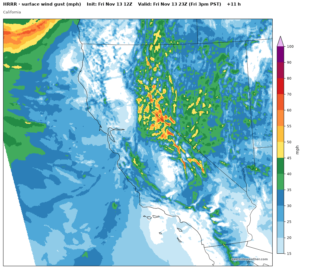
Ridgetop winds will be very strong, gusting 60-80 mph, and strong winds will couple down to the surface along 395, gusting 40-55 mph at times.
Snow levels appear to start out a hair lower than shown a few days ago, around 7,000 feet Friday afternoon. They will then fall to around 6,000 feet Friday evening and to around 5,000 feet by Saturday morning with the colder air behind the front. The heaviest snow falls from about 4 PM to midnight, with rates of 1 to 3 inches per hour at times. Travel may be very difficult to impossible Friday evening, especially if winds contribute to poor visibility.
How much?
The models are generally aligned on precipitation amounts, all showing around 0.85-1.15" of liquid at Main Lodge through Saturday. As mentioned, the HRRR is a notable outlier, showing around 1.6". It can often overdo post-frontal convection in our area, but the possibility is there for higher-end totals.
Due to heavy winds and a warm start, we're looking at around 7:1 or 8:1 ratios. Other sites and forecasters show more, but I'm sticking to my guns, which tell me that the extreme winds coupling to the surface will result in less measurable snow from the same amount of liquid.
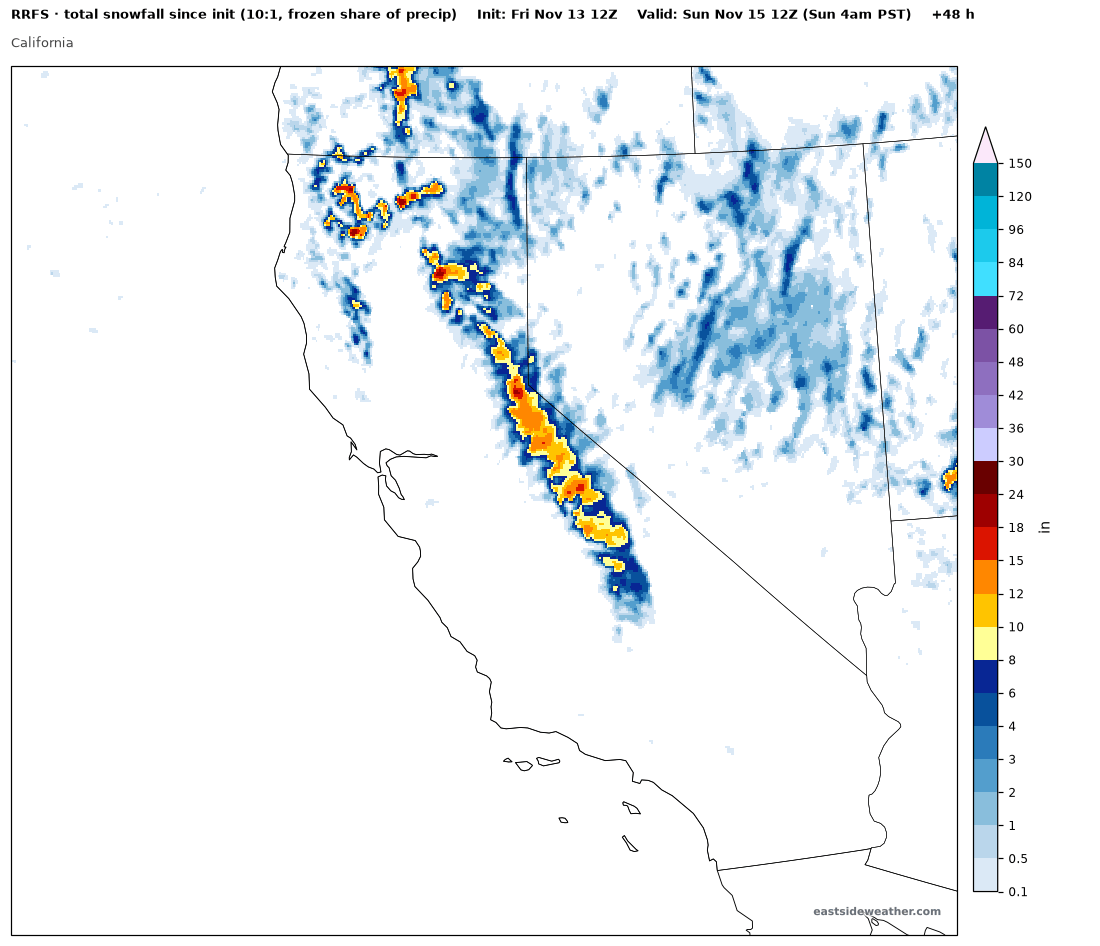
Here are the RRFS snowfall totals. Keep in mind this map uses a 10:1 ratio, so with our dense snow, I'd trim these numbers a bit.
Putting it all together, between Friday & Saturday I'm thinking:
- Main Lodge: 6-10"
- Town of Mammoth Lakes: 4-7" (warm ground will hinder accumulation early on)
- Summit of Mammoth Mountain and higher peaks: up to 15"
If winds come in lighter, then my forecast will be on the low end.
Not a bad base builder for mid November.
Monday: a colder storm
Another colder system is close behind late Sunday thru Monday. There is still some uncertainty here, and there are notable outliers like the ICON, which shows a wetter solution with around 0.5" of liquid at Main Lodge. Most models show around 0.2-0.4" of liquid, however.
As of right now, I'm expecting just 2-4" of snow with this one. Snow levels start around 6,000 feet and fall below 5,000 feet on the tail end of the system. That's higher than the 2,500-3,500 feet models showed earlier this week, as snow levels for Monday have been trending up.
Wednesday: a potentially much wetter storm
Next Weds / Thurs, a potentially much wetter storm has been showing up on models for a while now.
The plume below shows the thinking of some of the operational models and ensembles. Of particular note is WeatherNext 3, which appears to be fully bought into the wetter look for the storm. However, AIFS ENS and others are not yet bought in, so confidence is naturally lower at this time.
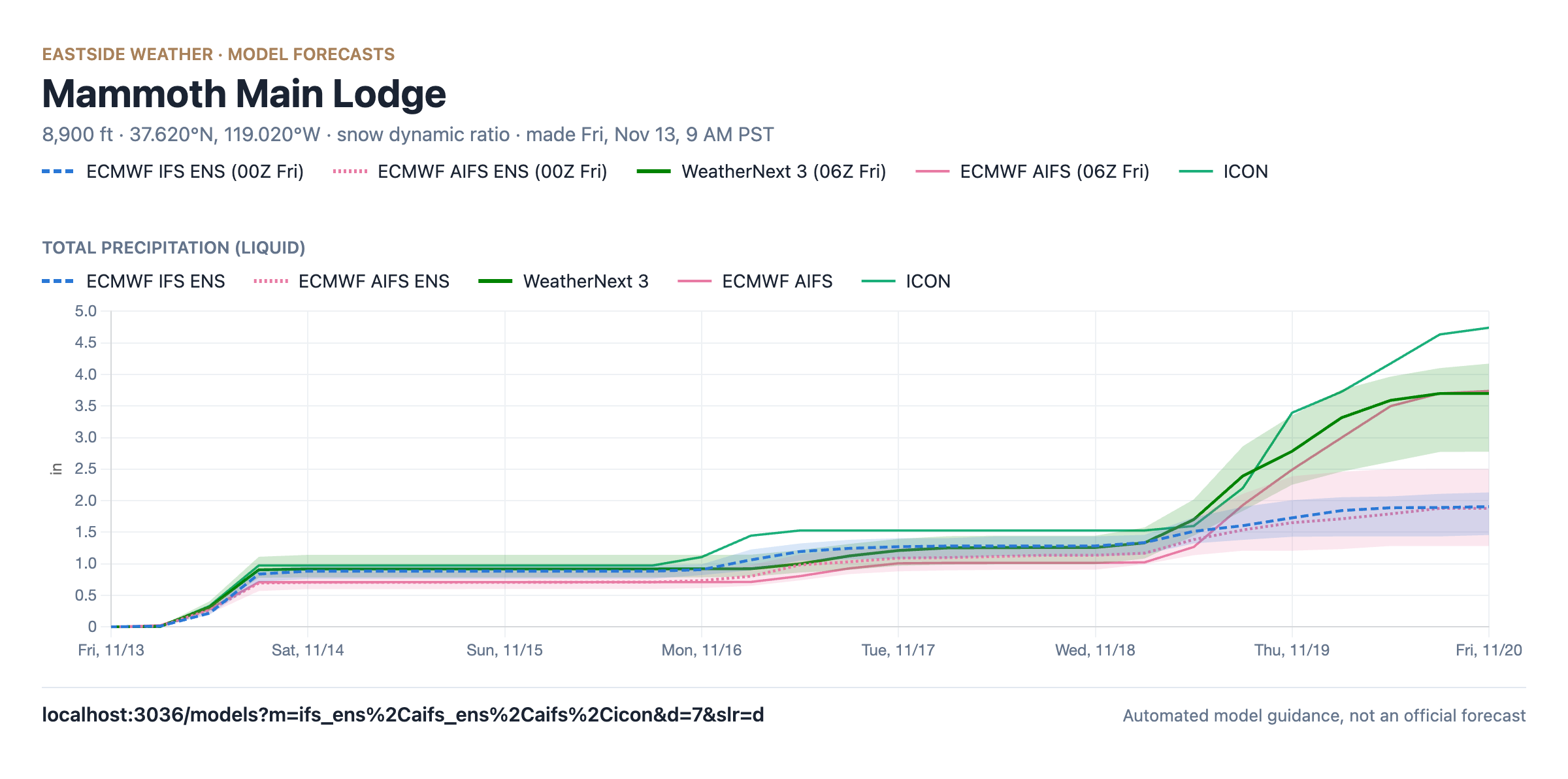
Not all scenarios from the other ensembles are bought into closing the low off and keeping it off shore like WN3 is. However, if WN3 is correct, we could be looking at a multi foot storm... Something to watch now.
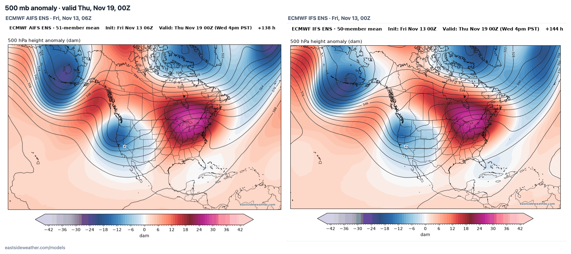
WN3 shows a much more coherent closed low off shore. The operational models like AIFS, ICON, GDPS, and GFS are all bought into this, but their ensembles are split.
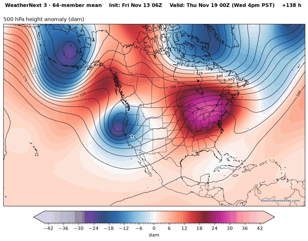
WeatherNext 3: © 2024-6 Google LLC, whose machine learning models were used to create the experimental data made available under the following licence terms https://storage.googleapis.com/weathernext-public/terms-of-use.pdf. This data is intended for experimental modelling only and is not intended, validated, or approved for real world use.
This storm could potentially be a closed low making a direct pass over California, bringing strong frontal dynamics and very heavy rain and snow over the course of nearly two days. But still too far out to count on with the ensemble spread.
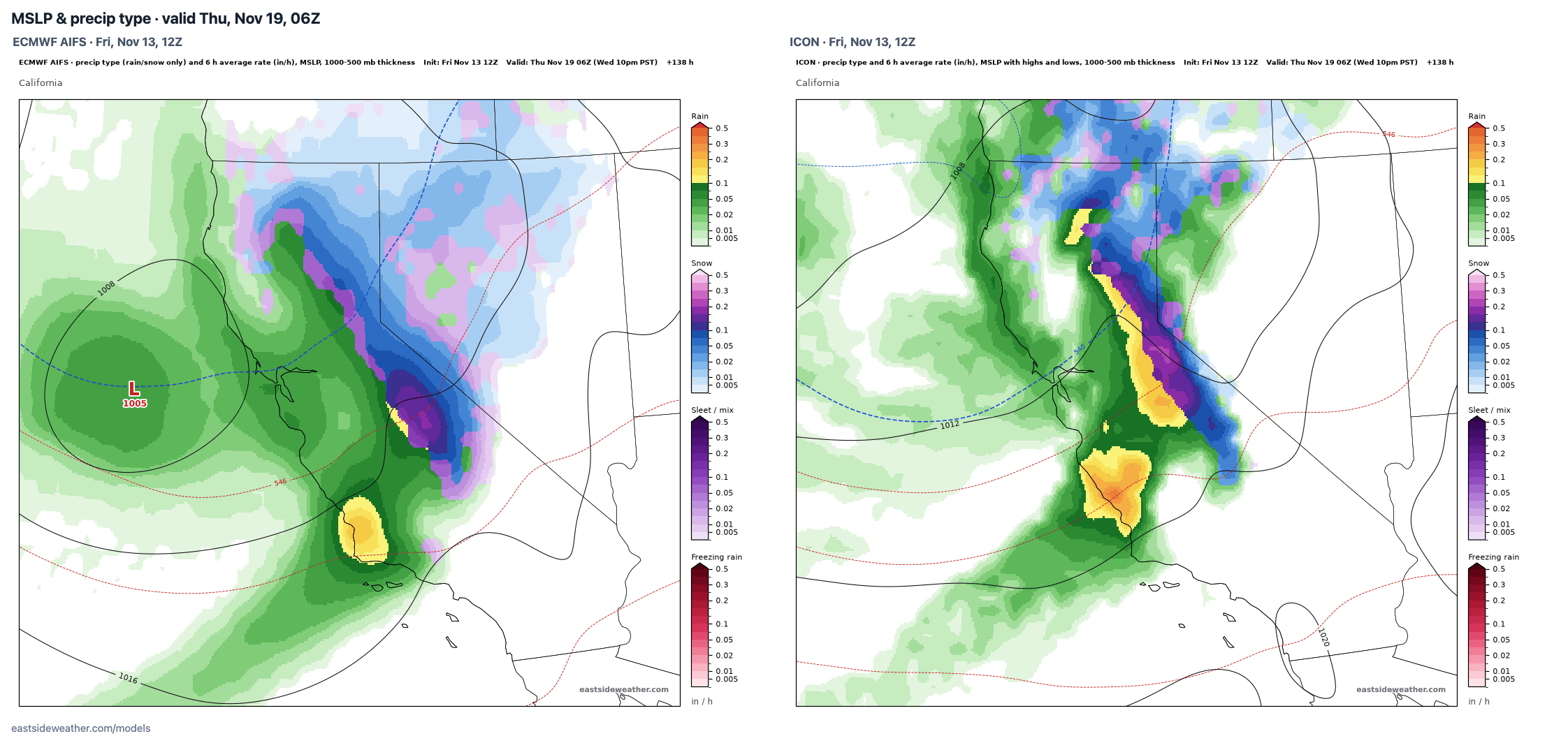
WeatherNext 3 has been performing well so far, and this will be a great litmus test to see if it is a notch above the AIFS.
The extended range: the Gulf of Alaska trough sticks around
Looking further ahead, a Gulf of Alaska trough is favored across ensembles, and has support from our El Niño and the MJO currently in phases 2-3.
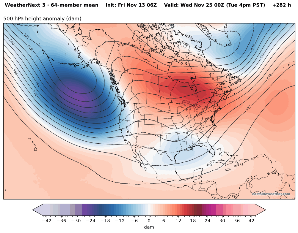
This keeps the storm door open, and this possibility is reflected in ensembles. An open storm door isn't a guarantee. One storm at a time!
Recap
- Friday into Saturday: 6-10" at Main Lodge, 4-7" in Mammoth Lakes, up to 15" on the summit. Very strong winds and difficult travel Friday evening.
- Monday: a colder storm, 2-4" for now, with some uncertainty.
- Wednesday into Thursday: a potentially much wetter storm trending, but still too early for numbers.
- Thanksgiving week: Gulf of Alaska troughing likely continues, and so do our storm chances.
Let it snow!
Enjoying the forecasts?
Eastside Weather is a passion project, but keeping it running comes with steady monthly costs: hosting, data feeds and the servers that crunch the model runs. Right now the site costs more than it brings in. Whatever you chip in goes straight back into keeping it going and building new tools.